El Edén geodata
El Edén (Chiapas) is a populated place; located in Mexico in America/Mexico_City (GMT-6) time zone. With population of 764 people, there are 11465 cities with bigger population in this country. Compared to other cities in Mexico, 85.6% of cities are located further ↑North; 96.2% of cities are located further ←West and 80.9% of cities have higher elevation than El Edén. Note1


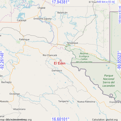
El Edén GPS coordinates[2]
17° 16' 25.068" North, 91° 33' 30.06" West
| Map corner | latitude | longitude |
|---|---|---|
| Upper-left | 17.94381°, | -92.26148° |
| Center: | 17.27363°, | -91.55835° |
| Lower-right: | 16.60101°, | -90.85523° |
| Map W x H: | 149.3×149.3 km | = 92.8×92.8mi |
| max Lat: | 32.7° ⇑85.6% North |
| El Edén: | 17.27363° |
| min Lat: | ⇓14.4% South 14.53588° |
| min Long | El Edén | max Long |
| -117.105° | -91.55835° | -86.73105° |
| W 96.2%⇐ | ⇒3.8% E |
Elevation
Elevation of El Edén is 83 m = 272 ft, and this is 1170.7 m = 3841 ft below average elevation for this country.
| Max E: |
3497 m = 11473 ft | 80.9% |
| Avg. | 1253.7 m = 4113 ft | |
| El Edén | 83 m = 272 ft | |
Min E: |
-1 m = -3 ft | 19.1% |
See also: Mexico elevation on elevation.city.
Geographical zone
El Edén is located in North Torrid zone (between Equator and Tropic of Cancer). Distance of this Northern Tropic circle is 685.3 km =425.8 mi to North.| Distance of | km | miles | from El Edén |
|---|---|---|---|
| North Pole | 8086.4 | 5024.7 | to North |
| Arctic Circle | 5480.5 | 3405.4 | to North |
| Tropic Cancer | 685.3 | 425.8 | to North |
| Equator | 1920.6 | 1193.4 | to South |


Nearby cities:
15 places around El Edén: (largest is in red/bold)
• Arena de Hidalgo
20.8 km =12.9 mi,  351°
351°
• Cristóbal Colón
11.8 km =7.3 mi,  219°
219°
• Damasco
13.2 km =8.2 mi,  199°
199°
• El Clavo
14.5 km =9 mi,  328°
328°
• Francisco Guerrero
17.7 km =11 mi,  154°
154°
• Jol Tulijá
19.6 km =12.2 mi,  234°
234°
• La Arena
18.1 km =11.2 mi,  167°
167°
• La Reforma de Ocampo
15.1 km =9.4 mi,  287°
287°
• Lázaro Cárdenas
9.8 km =6.1 mi,  4°
4°
• Nueva Samaria
10.3 km =6.4 mi,  213°
213°
• Nuevo Jericó
15.9 km =9.9 mi, 174°
• Río Chancalá
15 km =9.3 mi,  296°
296°
• San José Pathuitz
14.5 km =9 mi, 229°
• San Juan Chancalaíto
19.4 km =12.1 mi, 293°
• San Martín Chamizal
5.3 km =3.3 mi,  259°
259°
Sources, notices
• [Note1] Compared only with cities in Mexico existing in our database
• [Src1] Map data: © OpenStreetMap contributors (CC-BY-SA)
• [Src2] Other city data from geonames.org with taken over terms of usage.
• [Src3] Geographical zone / Annual Mean Temperature by Robert A. Rohde @ Wikipedia
