Cristóbal Colón geodata
Cristóbal Colón (Chiapas) is a populated place; located in Mexico in America/Mexico_City (GMT-6) time zone. With population of 1,623 people, there are 5331 cities with bigger population in this country. Compared to other cities in Mexico, 86.7% of cities are located further ↑North; 96.1% of cities are located further ←West and 72.3% of cities have higher elevation than Cristóbal Colón. Note1


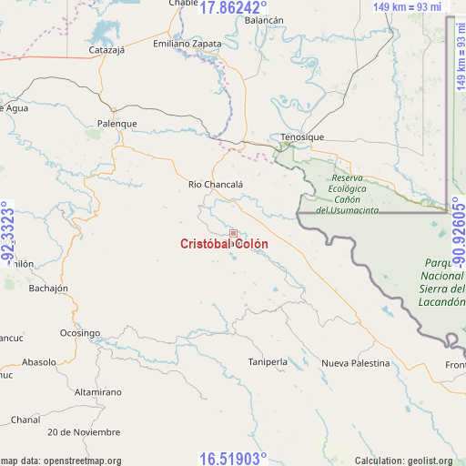
Cristóbal Colón GPS coordinates[2]
17° 11' 30.984" North, 91° 37' 45.012" West
| Map corner | latitude | longitude |
|---|---|---|
| Upper-left | 17.86242°, | -92.3323° |
| Center: | 17.19194°, | -91.62917° |
| Lower-right: | 16.51903°, | -90.92605° |
| Map W x H: | 149.4×149.4 km | = 92.8×92.8mi |
| max Lat: | 32.7° ⇑86.7% North |
| Cristóbal Colón: | 17.19194° |
| min Lat: | ⇓13.3% South 14.53588° |
| min Long | Cristóbal Col� | max Long |
| -117.105° | -91.62917° | -86.73105° |
| W 96.1%⇐ | ⇒3.9% E |
Elevation
Elevation of Cristóbal Colón is 318 m = 1043 ft, and this is 935.7 m = 3070 ft below average elevation for this country.
| Max E: |
3497 m = 11473 ft | 72.3% |
| Avg. | 1253.7 m = 4113 ft | |
| Cristóbal Colón | 318 m = 1043 ft | |
Min E: |
-1 m = -3 ft | 27.7% |
See also: Mexico elevation on elevation.city.
Geographical zone
Cristóbal Colón is located in North Torrid zone (between Equator and Tropic of Cancer). Distance of this Northern Tropic circle is 694.4 km =431.5 mi to North.| Distance of | km | miles | from Cristóbal Colón |
|---|---|---|---|
| North Pole | 8095.5 | 5030.3 | to North |
| Arctic Circle | 5489.6 | 3411.1 | to North |
| Tropic Cancer | 694.4 | 431.5 | to North |
| Equator | 1911.6 | 1187.8 | to South |


Nearby cities:
15 places around Cristóbal Colón: (largest is in red/bold)
• Damasco
4.5 km =2.8 mi,  137°
137°
• El Diamante
11.9 km =7.4 mi,  236°
236°
• El Edén
11.8 km =7.3 mi,  39°
39°
• El Tumbo
12.7 km =7.9 mi,  178°
178°
• Francisco Guerrero
16.6 km =10.3 mi,  114°
114°
• Jol Tulijá
8.8 km =5.5 mi,  255°
255°
• La Arena
14.2 km =8.8 mi,  127°
127°
• La Reforma de Ocampo
15.2 km =9.4 mi,  332°
332°
• Nueva Esperanza (La Esperanza)
10.3 km =6.4 mi,  209°
209°
• Nueva Samaria
1.9 km =1.2 mi,  74°
74°
• Nuevo Jericó
11.4 km =7.1 mi, 126°
• Nuevo San Joaquín
16.7 km =10.4 mi,  305°
305°
• Peña Limonar
11.5 km =7.1 mi,  226°
226°
• San José Pathuitz
3.5 km =2.2 mi, 262°
• San Martín Chamizal
8.5 km =5.3 mi,  15°
15°
Sources, notices
• [Note1] Compared only with cities in Mexico existing in our database
• [Src1] Map data: © OpenStreetMap contributors (CC-BY-SA)
• [Src2] Other city data from geonames.org with taken over terms of usage.
• [Src3] Geographical zone / Annual Mean Temperature by Robert A. Rohde @ Wikipedia
