San Martín Chamizal geodata
San Martín Chamizal (Chiapas) is a populated place; located in Mexico in America/Mexico_City (GMT-6) time zone. With population of 789 people, there are 11068 cities with bigger population in this country. Compared to other cities in Mexico, 85.7% of cities are located further ↑North; 96.2% of cities are located further ←West and 76.7% of cities have higher elevation than San Martín Chamizal. Note1


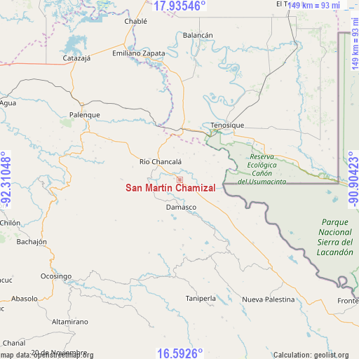
San Martín Chamizal GPS coordinates[2]
17° 15' 54.9" North, 91° 36' 26.46" West
| Map corner | latitude | longitude |
|---|---|---|
| Upper-left | 17.93546°, | -92.31048° |
| Center: | 17.26525°, | -91.60735° |
| Lower-right: | 16.5926°, | -90.90423° |
| Map W x H: | 149.3×149.3 km | = 92.8×92.8mi |
| max Lat: | 32.7° ⇑85.7% North |
| San Martín Chamizal: | 17.26525° |
| min Lat: | ⇓14.3% South 14.53588° |
| min Long | San Martín Cha | max Long |
| -117.105° | -91.60735° | -86.73105° |
| W 96.2%⇐ | ⇒3.8% E |
Elevation
Elevation of San Martín Chamizal is 162 m = 531 ft, and this is 1091.7 m = 3582 ft below average elevation for this country.
| Max E: |
3497 m = 11473 ft | 76.7% |
| Avg. | 1253.7 m = 4113 ft | |
| San Martín Chamizal | 162 m = 531 ft | |
Min E: |
-1 m = -3 ft | 23.3% |
See also: Mexico elevation on elevation.city.
Geographical zone
San Martín Chamizal is located in North Torrid zone (between Equator and Tropic of Cancer). Distance of this Northern Tropic circle is 686.2 km =426.4 mi to North.| Distance of | km | miles | from San Martín Chamizal |
|---|---|---|---|
| North Pole | 8087.3 | 5025.2 | to North |
| Arctic Circle | 5481.5 | 3406 | to North |
| Tropic Cancer | 686.2 | 426.4 | to North |
| Equator | 1919.7 | 1192.8 | to South |


Nearby cities:
15 places around San Martín Chamizal: (largest is in red/bold)
• Cristóbal Colón
8.5 km =5.3 mi,  195°
195°
• Damasco
11.5 km =7.1 mi,  176°
176°
• El Clavo
13.5 km =8.4 mi,  349°
349°
• El Edén
5.3 km =3.3 mi,  79°
79°
• Jol Tulijá
15 km =9.3 mi,  226°
226°
• La Arena
19 km =11.8 mi,  151°
151°
• La Reforma de Ocampo
10.7 km =6.6 mi,  300°
300°
• Lázaro Cárdenas
12.2 km =7.6 mi,  28°
28°
• Nueva Esperanza (La Esperanza)
18.6 km =11.6 mi, 203°
• Nueva Samaria
7.7 km =4.8 mi, 183°
• Nuevo Jericó
16.4 km =10.2 mi,  155°
155°
• Nuevo San Joaquín
16.1 km =10 mi,  275°
275°
• Río Chancalá
11.2 km =7 mi,  313°
313°
• San José Pathuitz
10.4 km =6.5 mi,  213°
213°
• San Juan Chancalaíto
15.3 km =9.5 mi, 304°
Sources, notices
• [Note1] Compared only with cities in Mexico existing in our database
• [Src1] Map data: © OpenStreetMap contributors (CC-BY-SA)
• [Src2] Other city data from geonames.org with taken over terms of usage.
• [Src3] Geographical zone / Annual Mean Temperature by Robert A. Rohde @ Wikipedia
