Hidalgo Joshil geodata
Hidalgo Joshil (Chiapas) is a populated place; located in Mexico in America/Mexico_City (GMT-6) time zone. With population of 2,496 people, there are 3539 cities with bigger population in this country. Compared to other cities in Mexico, 86.2% of cities are located further ↑North; 93.1% of cities are located further ←West and 65.4% of cities have higher elevation than Hidalgo Joshil. Note1


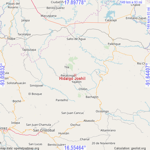
Hidalgo Joshil GPS coordinates[2]
17° 13' 38.748" North, 92° 20' 49.884" West
| Map corner | latitude | longitude |
|---|---|---|
| Upper-left | 17.89778°, | -93.05032° |
| Center: | 17.22743°, | -92.34719° |
| Lower-right: | 16.55464°, | -91.64407° |
| Map W x H: | 149.3×149.3 km | = 92.8×92.8mi |
| max Lat: | 32.7° ⇑86.2% North |
| Hidalgo Joshil: | 17.22743° |
| min Lat: | ⇓13.8% South 14.53588° |
| min Long | Hidalgo Joshil | max Long |
| -117.105° | -92.34719° | -86.73105° |
| W 93.1%⇐ | ⇒6.9% E |
Elevation
Elevation of Hidalgo Joshil is 666 m = 2185 ft, and this is 587.7 m = 1928 ft below average elevation for this country.
| Max E: |
3497 m = 11473 ft | 65.4% |
| Avg. | 1253.7 m = 4113 ft | |
| Hidalgo Joshil | 666 m = 2185 ft | |
Min E: |
-1 m = -3 ft | 34.6% |
See also: Mexico elevation on elevation.city.
Geographical zone
Hidalgo Joshil is located in North Torrid zone (between Equator and Tropic of Cancer). Distance of this Northern Tropic circle is 690.4 km =429 mi to North.| Distance of | km | miles | from Hidalgo Joshil |
|---|---|---|---|
| North Pole | 8091.6 | 5027.9 | to North |
| Arctic Circle | 5485.7 | 3408.7 | to North |
| Tropic Cancer | 690.4 | 429 | to North |
| Equator | 1915.5 | 1190.2 | to South |


Nearby cities:
15 places around Hidalgo Joshil: (largest is in red/bold)
• Aurora Grande
10.5 km =6.5 mi,  184°
184°
• Benito Juárez
10.3 km =6.4 mi,  70°
70°
• Cantioc
7.4 km =4.6 mi,  301°
301°
• Chilón
7.4 km =4.6 mi,  275°
275°
• El Recreo
10.1 km =6.3 mi,  203°
203°
• Joljamil
4.7 km =2.9 mi,  34°
34°
• Joshil
2.7 km =1.7 mi,  322°
322°
• Lázaro Cárdenas
4.9 km =3 mi,  227°
227°
• Misija
5.6 km =3.5 mi, 319°
• Petalcingo
7.2 km =4.5 mi,  269°
269°
• Río Grande
8.4 km =5.2 mi, 299°
• Tocob Leglemal
3.4 km =2.1 mi, 282°
• Tumbala
6.4 km =4 mi, 29°
• Unión Juárez
8.1 km =5 mi, 316°
• Yajalón
6.3 km =3.9 mi,  166°
166°
Sources, notices
• [Note1] Compared only with cities in Mexico existing in our database
• [Src1] Map data: © OpenStreetMap contributors (CC-BY-SA)
• [Src2] Other city data from geonames.org with taken over terms of usage.
• [Src3] Geographical zone / Annual Mean Temperature by Robert A. Rohde @ Wikipedia
