Joshil geodata
Joshil (Chiapas) is a populated place; located in Mexico in America/Mexico_City (GMT-6) time zone. With population of 3,110 people, there are 2905 cities with bigger population in this country. Compared to other cities in Mexico, 85.9% of cities are located further ↑North; 93% of cities are located further ←West and 59.3% of cities have higher elevation than Joshil. Note1


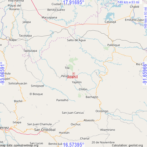
Joshil GPS coordinates[2]
17° 14' 48.012" North, 92° 21' 46.008" West
| Map corner | latitude | longitude |
|---|---|---|
| Upper-left | 17.91695°, | -93.06591° |
| Center: | 17.24667°, | -92.36278° |
| Lower-right: | 16.57395°, | -91.65966° |
| Map W x H: | 149.3×149.3 km | = 92.8×92.8mi |
| max Lat: | 32.7° ⇑85.9% North |
| Joshil: | 17.24667° |
| min Lat: | ⇓14.1% South 14.53588° |
| min Long | Joshil | max Long |
| -117.105° | -92.36278° | -86.73105° |
| W 93%⇐ | ⇒7% E |
Elevation
Elevation of Joshil is 1034 m = 3392 ft, and this is 219.7 m = 721 ft below average elevation for this country.
| Max E: |
3497 m = 11473 ft | 59.3% |
| Avg. | 1253.7 m = 4113 ft | |
| Joshil | 1034 m = 3392 ft | |
Min E: |
-1 m = -3 ft | 40.7% |
See also: Mexico elevation on elevation.city.
Geographical zone
Joshil is located in North Torrid zone (between Equator and Tropic of Cancer). Distance of this Northern Tropic circle is 688.3 km =427.7 mi to North.| Distance of | km | miles | from Joshil |
|---|---|---|---|
| North Pole | 8089.4 | 5026.5 | to North |
| Arctic Circle | 5483.5 | 3407.3 | to North |
| Tropic Cancer | 688.3 | 427.7 | to North |
| Equator | 1917.6 | 1191.5 | to South |


Nearby cities:
15 places around Joshil: (largest is in red/bold)
• Cantioc
5 km =3.1 mi,  290°
290°
• Chilón
5.9 km =3.7 mi,  255°
255°
• Hidalgo Joshil
2.7 km =1.7 mi,  142°
142°
• Joljamil
4.6 km =2.9 mi,  68°
68°
• Jolpokitioc
9.7 km =6 mi, 287°
• Lázaro Cárdenas
5.8 km =3.6 mi,  199°
199°
• Misija
2.9 km =1.8 mi,  317°
317°
• Petalcingo
6 km =3.7 mi,  248°
248°
• Río Grande
6.1 km =3.8 mi, 289°
• Tila
9.1 km =5.7 mi,  311°
311°
• Tocob Leglemal
2.2 km =1.4 mi,  229°
229°
• Tumbala
5.9 km =3.7 mi,  54°
54°
• Unión Juárez
5.5 km =3.4 mi, 314°
• Yajalón
8.8 km =5.5 mi,  159°
159°
• Yok Pokitiok
8.7 km =5.4 mi,  278°
278°
Sources, notices
• [Note1] Compared only with cities in Mexico existing in our database
• [Src1] Map data: © OpenStreetMap contributors (CC-BY-SA)
• [Src2] Other city data from geonames.org with taken over terms of usage.
• [Src3] Geographical zone / Annual Mean Temperature by Robert A. Rohde @ Wikipedia
