Aurora Grande geodata
Aurora Grande (Chiapas) is a populated place; located in Mexico in America/Mexico_City (GMT-6) time zone. With population of 990 people, there are 8795 cities with bigger population in this country. Compared to other cities in Mexico, 87.3% of cities are located further ↑North; 93% of cities are located further ←West and 50.1% of cities have higher elevation than Aurora Grande. Note1


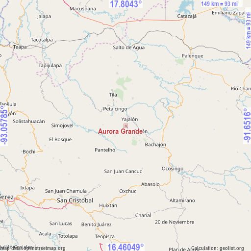
Aurora Grande GPS coordinates[2]
17° 8' 0.996" North, 92° 21' 16.992" West
| Map corner | latitude | longitude |
|---|---|---|
| Upper-left | 17.8043°, | -93.05785° |
| Center: | 17.13361°, | -92.35472° |
| Lower-right: | 16.46049°, | -91.6516° |
| Map W x H: | 149.4×149.4 km | = 92.8×92.8mi |
| max Lat: | 32.7° ⇑87.3% North |
| Aurora Grande: | 17.13361° |
| min Lat: | ⇓12.7% South 14.53588° |
| min Long | Aurora Grande | max Long |
| -117.105° | -92.35472° | -86.73105° |
| W 93%⇐ | ⇒7% E |
Elevation
Elevation of Aurora Grande is 1427 m = 4682 ft, and this is 173.3 m = 569 ft above average elevation for this country.
| Max E: |
3497 m = 11473 ft | 50.1% |
| Aurora Grande | 1427 m 4682 ft | |
| Avg. | 1253.7 m = 4113 ft | |
Min E: |
-1 m = -3 ft | 49.9% |
See also: Mexico elevation on elevation.city.
Geographical zone
Aurora Grande is located in North Torrid zone (between Equator and Tropic of Cancer). Distance of this Northern Tropic circle is 700.8 km =435.5 mi to North.| Distance of | km | miles | from Aurora Grande |
|---|---|---|---|
| North Pole | 8102 | 5034.3 | to North |
| Arctic Circle | 5496.1 | 3415.1 | to North |
| Tropic Cancer | 700.8 | 435.5 | to North |
| Equator | 1905.1 | 1183.8 | to South |


Nearby cities:
15 places around Aurora Grande: (largest is in red/bold)
• Chilón
9.2 km =5.7 mi,  109°
109°
• El Recreo
3.4 km =2.1 mi,  290°
290°
• Emiliano Zapata
6.9 km =4.3 mi,  281°
281°
• Golonchán Viejo
11.8 km =7.3 mi,  195°
195°
• Hidalgo Joshil
10.5 km =6.5 mi,  4°
4°
• Insurgente Picoté
8.7 km =5.4 mi, 200°
• Juan Sabines Verapaz
7.8 km =4.8 mi,  144°
144°
• Lázaro Cárdenas
7.7 km =4.8 mi,  338°
338°
• Petalcingo
12.2 km =7.6 mi,  328°
328°
• Santa Cruz la Reforma
10.8 km =6.7 mi,  145°
145°
• Tacuba Nueva
5.1 km =3.2 mi, 198°
• Tocob Leglemal
11.4 km =7.1 mi,  347°
347°
• Tzajalá
4.1 km =2.5 mi,  273°
273°
• Tzasibiltic
7.2 km =4.5 mi,  77°
77°
• Yajalón
4.9 km =3 mi,  27°
27°
Sources, notices
• [Note1] Compared only with cities in Mexico existing in our database
• [Src1] Map data: © OpenStreetMap contributors (CC-BY-SA)
• [Src2] Other city data from geonames.org with taken over terms of usage.
• [Src3] Geographical zone / Annual Mean Temperature by Robert A. Rohde @ Wikipedia
