Nuevo Limar geodata
Nuevo Limar (Chiapas) is a populated place; located in Mexico in America/Mexico_City (GMT-6) time zone. With population of 1,974 people, there are 4418 cities with bigger population in this country. Compared to other cities in Mexico, 83.6% of cities are located further ↑North; 92.8% of cities are located further ←West and 83% of cities have higher elevation than Nuevo Limar. Note1


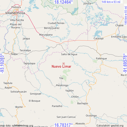
Nuevo Limar GPS coordinates[2]
17° 27' 18.504" North, 92° 23' 56.04" West
| Map corner | latitude | longitude |
|---|---|---|
| Upper-left | 18.12464°, | -93.10203° |
| Center: | 17.45514°, | -92.3989° |
| Lower-right: | 16.78317°, | -91.69578° |
| Map W x H: | 149.2×149.2 km | = 92.7×92.7mi |
| max Lat: | 32.7° ⇑83.6% North |
| Nuevo Limar: | 17.45514° |
| min Lat: | ⇓16.4% South 14.53588° |
| min Long | Nuevo Limar | max Long |
| -117.105° | -92.3989° | -86.73105° |
| W 92.8%⇐ | ⇒7.2% E |
Elevation
Elevation of Nuevo Limar is 60 m = 197 ft, and this is 1193.7 m = 3916 ft below average elevation for this country.
| Max E: |
3497 m = 11473 ft | 83% |
| Avg. | 1253.7 m = 4113 ft | |
| Nuevo Limar | 60 m = 197 ft | |
Min E: |
-1 m = -3 ft | 17% |
See also: Mexico elevation on elevation.city.
Geographical zone
Nuevo Limar is located in North Torrid zone (between Equator and Tropic of Cancer). Distance of this Northern Tropic circle is 665.1 km =413.3 mi to North.| Distance of | km | miles | from Nuevo Limar |
|---|---|---|---|
| North Pole | 8066.2 | 5012.1 | to North |
| Arctic Circle | 5460.3 | 3392.9 | to North |
| Tropic Cancer | 665.1 | 413.3 | to North |
| Equator | 1940.8 | 1206 | to South |


Nearby cities:
15 places around Nuevo Limar: (largest is in red/bold)
• Campanario
5.2 km =3.2 mi,  75°
75°
• Cenobio Aguilar (La Trinidad)
10.1 km =6.3 mi,  123°
123°
• El Carrizal
12 km =7.5 mi,  190°
190°
• El Crucero
11.7 km =7.3 mi,  215°
215°
• El Limar
4.5 km =2.8 mi, 185°
• El Progreso
5.9 km =3.7 mi,  150°
150°
• Jochinteol
5.6 km =3.5 mi,  0°
0°
• La Esperanza del Porvenir
11.9 km =7.4 mi, 149°
• Libertad Jolnishtie 2da. Sección
12.1 km =7.5 mi,  256°
256°
• Los Luceros 2da. Sección
8.6 km =5.3 mi,  342°
342°
• Mariscal Yehuitz
12.3 km =7.6 mi,  162°
162°
• Paso Chinal
12.9 km =8 mi,  290°
290°
• Salto de Agua
12.7 km =7.9 mi,  29°
29°
• Tza'Quil
10 km =6.2 mi,  232°
232°
• Usipa
6.5 km =4 mi,  320°
320°
Sources, notices
• [Note1] Compared only with cities in Mexico existing in our database
• [Src1] Map data: © OpenStreetMap contributors (CC-BY-SA)
• [Src2] Other city data from geonames.org with taken over terms of usage.
• [Src3] Geographical zone / Annual Mean Temperature by Robert A. Rohde @ Wikipedia
