La Nueva geodata
La Nueva (Chiapas) is a populated place; located in Mexico in America/Mexico_City (GMT-6) time zone. With population of 643 people, there are 13457 cities with bigger population in this country. Compared to other cities in Mexico, 88.2% of cities are located further ↑North; 87.7% of cities are located further ←West and 65.9% of cities have higher elevation than La Nueva. Note1


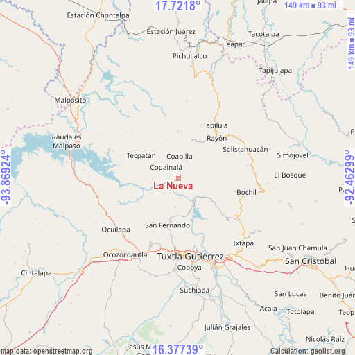
La Nueva GPS coordinates[2]
17° 3' 2.88" North, 93° 9' 57.996" West
| Map corner | latitude | longitude |
|---|---|---|
| Upper-left | 17.7218°, | -93.86924° |
| Center: | 17.0508°, | -93.16611° |
| Lower-right: | 16.37739°, | -92.46299° |
| Map W x H: | 149.5×149.5 km | = 92.9×92.9mi |
| max Lat: | 32.7° ⇑88.2% North |
| La Nueva: | 17.0508° |
| min Lat: | ⇓11.8% South 14.53588° |
| min Long | La Nueva | max Long |
| -117.105° | -93.16611° | -86.73105° |
| W 87.7%⇐ | ⇒12.3% E |
Elevation
Elevation of La Nueva is 640 m = 2100 ft, and this is 613.7 m = 2013 ft below average elevation for this country.
| Max E: |
3497 m = 11473 ft | 65.9% |
| Avg. | 1253.7 m = 4113 ft | |
| La Nueva | 640 m = 2100 ft | |
Min E: |
-1 m = -3 ft | 34.1% |
See also: Mexico elevation on elevation.city.
Geographical zone
La Nueva is located in North Torrid zone (between Equator and Tropic of Cancer). Distance of this Northern Tropic circle is 710 km =441.2 mi to North.| Distance of | km | miles | from La Nueva |
|---|---|---|---|
| North Pole | 8111.2 | 5040.1 | to North |
| Arctic Circle | 5505.3 | 3420.8 | to North |
| Tropic Cancer | 710 | 441.2 | to North |
| Equator | 1895.9 | 1178.1 | to South |


Nearby cities:
15 places around La Nueva: (largest is in red/bold)
• Benito Juárez
13.4 km =8.3 mi,  318°
318°
• Buenavista (Matasanos)
12.3 km =7.6 mi,  58°
58°
• Chicoasén
11.4 km =7.1 mi,  145°
145°
• Coapilla
9 km =5.6 mi,  4°
4°
• Copainalá
6.7 km =4.2 mi, 315°
• Cuauhtémoc
14.6 km =9.1 mi,  203°
203°
• El Carmelo
14.1 km =8.8 mi,  159°
159°
• Gabriel Esquinca
12.3 km =7.6 mi,  184°
184°
• José María Morelos y Pavón
4.4 km =2.7 mi,  54°
54°
• Julián Grajales (San Antonio)
13 km =8.1 mi,  308°
308°
• Llano Grande
7.2 km =4.5 mi,  36°
36°
• Miguel Hidalgo (Zacalapa)
10.2 km =6.3 mi,  332°
332°
• Rosario
9.2 km =5.7 mi,  297°
297°
• Vicente Guerrero
14.4 km =8.9 mi, 51°
• Ángel Albino Corzo (Guadalupe)
14.3 km =8.9 mi, 305°
Sources, notices
• [Note1] Compared only with cities in Mexico existing in our database
• [Src1] Map data: © OpenStreetMap contributors (CC-BY-SA)
• [Src2] Other city data from geonames.org with taken over terms of usage.
• [Src3] Geographical zone / Annual Mean Temperature by Robert A. Rohde @ Wikipedia
