Vicente Guerrero geodata
Vicente Guerrero (Chiapas) is a populated place; located in Mexico in America/Mexico_City (GMT-6) time zone. With population of 617 people, there are 13976 cities with bigger population in this country. Compared to other cities in Mexico, 87.3% of cities are located further ↑North; 88.3% of cities are located further ←West and 51.1% of cities have lower elevation than Vicente Guerrero. Note1


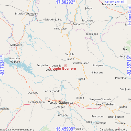
Vicente Guerrero GPS coordinates[2]
17° 7' 55.992" North, 93° 3' 37.008" West
| Map corner | latitude | longitude |
|---|---|---|
| Upper-left | 17.80292°, | -93.76341° |
| Center: | 17.13222°, | -93.06028° |
| Lower-right: | 16.45909°, | -92.35716° |
| Map W x H: | 149.4×149.4 km | = 92.8×92.8mi |
| max Lat: | 32.7° ⇑87.3% North |
| Vicente Guerrero: | 17.13222° |
| min Lat: | ⇓12.7% South 14.53588° |
| min Long | Vicente Guerrer | max Long |
| -117.105° | -93.06028° | -86.73105° |
| W 88.3%⇐ | ⇒11.7% E |
Elevation
Elevation of Vicente Guerrero is 1486 m = 4875 ft, and this is 232.3 m = 762 ft above average elevation for this country.
| Max E: |
3497 m = 11473 ft | 48.9% |
| Vicente Guerrero | 1486 m 4875 ft | |
| Avg. | 1253.7 m = 4113 ft | |
Min E: |
-1 m = -3 ft | 51.1% |
See also: Mexico elevation on elevation.city.
Geographical zone
Vicente Guerrero is located in North Torrid zone (between Equator and Tropic of Cancer). Distance of this Northern Tropic circle is 701 km =435.6 mi to North.| Distance of | km | miles | from Vicente Guerrero |
|---|---|---|---|
| North Pole | 8102.1 | 5034.4 | to North |
| Arctic Circle | 5496.2 | 3415.2 | to North |
| Tropic Cancer | 701 | 435.6 | to North |
| Equator | 1904.9 | 1183.6 | to South |


Nearby cities:
15 places around Vicente Guerrero: (largest is in red/bold)
• Buenavista (Matasanos)
2.8 km =1.7 mi,  194°
194°
• Coapilla
10.5 km =6.5 mi,  269°
269°
• El Amate
5.9 km =3.7 mi,  99°
99°
• El Carrizal
3.8 km =2.4 mi,  331°
331°
• El Triunfo
9.5 km =5.9 mi,  4°
4°
• Garrido Canaval
7.3 km =4.5 mi,  151°
151°
• José María Morelos y Pavón
10.1 km =6.3 mi,  229°
229°
• Julián Grajales
8.7 km =5.4 mi,  91°
91°
• Llano Grande
7.6 km =4.7 mi,  244°
244°
• Luis Espinoza
11.7 km =7.3 mi,  162°
162°
• Pantepec
6.3 km =3.9 mi,  9°
9°
• Rayón
9.3 km =5.8 mi,  34°
34°
• San Andrés Carrizal
12.8 km =8 mi,  316°
316°
• San Isidro las Banderas
10.9 km =6.8 mi, 0°
• Tapalapa
8.1 km =5 mi, 323°
Sources, notices
• [Note1] Compared only with cities in Mexico existing in our database
• [Src1] Map data: © OpenStreetMap contributors (CC-BY-SA)
• [Src2] Other city data from geonames.org with taken over terms of usage.
• [Src3] Geographical zone / Annual Mean Temperature by Robert A. Rohde @ Wikipedia
