Vicente Guerrero geodata
Vicente Guerrero (Chiapas) is a populated place; located in Mexico in America/Mexico_City (GMT-6) time zone. With population of 1,383 people, there are 6258 cities with bigger population in this country. Compared to other cities in Mexico, 93.2% of cities are located further ↑North; 86.4% of cities are located further ←West and 68.3% of cities have higher elevation than Vicente Guerrero. Note1


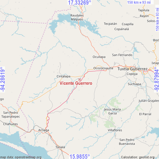
Vicente Guerrero GPS coordinates[2]
16° 39' 37.008" North, 93° 34' 59.016" West
| Map corner | latitude | longitude |
|---|---|---|
| Upper-left | 17.33269°, | -94.28619° |
| Center: | 16.66028°, | -93.58306° |
| Lower-right: | 15.9855°, | -92.87994° |
| Map W x H: | 149.8×149.8 km | = 93.1×93.1mi |
| max Lat: | 32.7° ⇑93.2% North |
| Vicente Guerrero: | 16.66028° |
| min Lat: | ⇓6.8% South 14.53588° |
| min Long | Vicente Guerrer | max Long |
| -117.105° | -93.58306° | -86.73105° |
| W 86.4%⇐ | ⇒13.6% E |
Elevation
Elevation of Vicente Guerrero is 507 m = 1663 ft, and this is 746.7 m = 2450 ft below average elevation for this country.
| Max E: |
3497 m = 11473 ft | 68.3% |
| Avg. | 1253.7 m = 4113 ft | |
| Vicente Guerrero | 507 m = 1663 ft | |
Min E: |
-1 m = -3 ft | 31.7% |
See also: Mexico elevation on elevation.city.
Geographical zone
Vicente Guerrero is located in North Torrid zone (between Equator and Tropic of Cancer). Distance of this Northern Tropic circle is 753.5 km =468.2 mi to North.| Distance of | km | miles | from Vicente Guerrero |
|---|---|---|---|
| North Pole | 8154.6 | 5067 | to North |
| Arctic Circle | 5548.7 | 3447.8 | to North |
| Tropic Cancer | 753.5 | 468.2 | to North |
| Equator | 1852.4 | 1151 | to South |


Nearby cities:
15 places around Vicente Guerrero: (largest is in red/bold)
• Abelardo L. Rodríguez
23.3 km =14.5 mi,  272°
272°
• Alfonso Moguel
8.2 km =5.1 mi,  84°
84°
• Cintalapa de Figueroa
14.6 km =9.1 mi,  280°
280°
• Cristóbal Colón
9.7 km =6 mi,  183°
183°
• Cuauhtémoc
18.7 km =11.6 mi,  229°
229°
• Espinal de Morelos
17.4 km =10.8 mi,  71°
71°
• Jacinto Tirado
21.5 km =13.4 mi,  286°
286°
• Jiquipilas
6.8 km =4.2 mi, 277°
• Luis Espinosa
21.7 km =13.5 mi, 180°
• Lázaro Cárdenas
23.1 km =14.4 mi,  254°
254°
• Miguel Hidalgo
13.6 km =8.5 mi,  215°
215°
• Nueva Palestina
19.4 km =12.1 mi,  196°
196°
• Quintana Roo
6.4 km =4 mi,  159°
159°
• Sinaloa
8.4 km =5.2 mi,  214°
214°
• Unión Agrarista
22.9 km =14.2 mi, 206°
Sources, notices
• [Note1] Compared only with cities in Mexico existing in our database
• [Src1] Map data: © OpenStreetMap contributors (CC-BY-SA)
• [Src2] Other city data from geonames.org with taken over terms of usage.
• [Src3] Geographical zone / Annual Mean Temperature by Robert A. Rohde @ Wikipedia
