Cristóbal Colón geodata
Cristóbal Colón (Chiapas) is a populated place; located in Mexico in America/Mexico_City (GMT-6) time zone. With population of 750 people, there are 11679 cities with bigger population in this country. Compared to other cities in Mexico, 93.8% of cities are located further ↑North; 86.4% of cities are located further ←West and 67.4% of cities have higher elevation than Cristóbal Colón. Note1


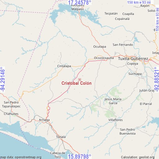
Cristóbal Colón GPS coordinates[2]
16° 34' 23.016" North, 93° 35' 17.988" West
| Map corner | latitude | longitude |
|---|---|---|
| Upper-left | 17.24578°, | -94.29146° |
| Center: | 16.57306°, | -93.58833° |
| Lower-right: | 15.89798°, | -92.88521° |
| Map W x H: | 149.9×149.9 km | = 93.1×93.1mi |
| max Lat: | 32.7° ⇑93.8% North |
| Cristóbal Colón: | 16.57306° |
| min Lat: | ⇓6.2% South 14.53588° |
| min Long | Cristóbal Col� | max Long |
| -117.105° | -93.58833° | -86.73105° |
| W 86.4%⇐ | ⇒13.6% E |
Elevation
Elevation of Cristóbal Colón is 563 m = 1847 ft, and this is 690.7 m = 2266 ft below average elevation for this country.
| Max E: |
3497 m = 11473 ft | 67.4% |
| Avg. | 1253.7 m = 4113 ft | |
| Cristóbal Colón | 563 m = 1847 ft | |
Min E: |
-1 m = -3 ft | 32.6% |
See also: Mexico elevation on elevation.city.
Geographical zone
Cristóbal Colón is located in North Torrid zone (between Equator and Tropic of Cancer). Distance of this Northern Tropic circle is 763.2 km =474.2 mi to North.| Distance of | km | miles | from Cristóbal Colón |
|---|---|---|---|
| North Pole | 8164.3 | 5073.1 | to North |
| Arctic Circle | 5558.4 | 3453.8 | to North |
| Tropic Cancer | 763.2 | 474.2 | to North |
| Equator | 1842.8 | 1145.1 | to South |


Nearby cities:
15 places around Cristóbal Colón: (largest is in red/bold)
• Alfonso Moguel
13.7 km =8.5 mi,  39°
39°
• Cintalapa de Figueroa
18.5 km =11.5 mi,  311°
311°
• Cristóbal Obregón
21 km =13 mi,  138°
138°
• Cuauhtémoc
13.9 km =8.6 mi,  259°
259°
• Jiquipilas
12.3 km =7.6 mi,  329°
329°
• José María Pino Suárez
17.7 km =11 mi,  245°
245°
• Julián Grajales
20.9 km =13 mi,  219°
219°
• Luis Espinosa
12 km =7.5 mi,  178°
178°
• Miguel Hidalgo
7.5 km =4.7 mi, 259°
• Nueva Palestina
10.1 km =6.3 mi,  208°
208°
• Nuevo México
19.7 km =12.2 mi,  125°
125°
• Quintana Roo
4.7 km =2.9 mi, 36°
• Sinaloa
5 km =3.1 mi,  303°
303°
• Unión Agrarista
14.5 km =9 mi, 222°
• Vicente Guerrero
9.7 km =6 mi,  3°
3°
Sources, notices
• [Note1] Compared only with cities in Mexico existing in our database
• [Src1] Map data: © OpenStreetMap contributors (CC-BY-SA)
• [Src2] Other city data from geonames.org with taken over terms of usage.
• [Src3] Geographical zone / Annual Mean Temperature by Robert A. Rohde @ Wikipedia
