Alfonso Moguel geodata
Alfonso Moguel (Chiapas) is a populated place; located in Mexico in America/Mexico_City (GMT-6) time zone. With population of 1,022 people, there are 8517 cities with bigger population in this country. Compared to other cities in Mexico, 93.1% of cities are located further ↑North; 86.5% of cities are located further ←West and 61.6% of cities have higher elevation than Alfonso Moguel. Note1


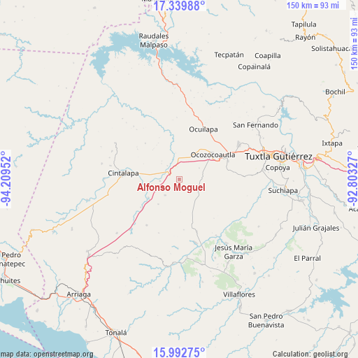
Alfonso Moguel GPS coordinates[2]
16° 40' 3" North, 93° 30' 23.004" West
| Map corner | latitude | longitude |
|---|---|---|
| Upper-left | 17.33988°, | -94.20952° |
| Center: | 16.6675°, | -93.50639° |
| Lower-right: | 15.99275°, | -92.80327° |
| Map W x H: | 149.8×149.8 km | = 93.1×93.1mi |
| max Lat: | 32.7° ⇑93.1% North |
| Alfonso Moguel: | 16.6675° |
| min Lat: | ⇓6.9% South 14.53588° |
| min Long | Alfonso Moguel | max Long |
| -117.105° | -93.50639° | -86.73105° |
| W 86.5%⇐ | ⇒13.5% E |
Elevation
Elevation of Alfonso Moguel is 903 m = 2963 ft, and this is 350.7 m = 1151 ft below average elevation for this country.
| Max E: |
3497 m = 11473 ft | 61.6% |
| Avg. | 1253.7 m = 4113 ft | |
| Alfonso Moguel | 903 m = 2963 ft | |
Min E: |
-1 m = -3 ft | 38.4% |
See also: Mexico elevation on elevation.city.
Geographical zone
Alfonso Moguel is located in North Torrid zone (between Equator and Tropic of Cancer). Distance of this Northern Tropic circle is 752.7 km =467.7 mi to North.| Distance of | km | miles | from Alfonso Moguel |
|---|---|---|---|
| North Pole | 8153.8 | 5066.5 | to North |
| Arctic Circle | 5547.9 | 3447.3 | to North |
| Tropic Cancer | 752.7 | 467.7 | to North |
| Equator | 1853.3 | 1151.6 | to South |


Nearby cities:
15 places around Alfonso Moguel: (largest is in red/bold)
• Cintalapa de Figueroa
22.6 km =14 mi,  274°
274°
• Ciudad Maya
21.8 km =13.5 mi,  68°
68°
• Cristóbal Colón
13.7 km =8.5 mi,  219°
219°
• Espinal de Morelos
9.5 km =5.9 mi,  61°
61°
• Guadalupe Victoria
18.8 km =11.7 mi,  103°
103°
• Hermenegildo Galeana
18.6 km =11.6 mi,  122°
122°
• Ignacio Zaragoza (El Morro)
18.2 km =11.3 mi,  114°
114°
• Jiquipilas
14.9 km =9.3 mi, 270°
• Miguel Hidalgo
20 km =12.4 mi,  233°
233°
• Nuevo México
23.2 km =14.4 mi,  161°
161°
• Ocozocoautla de Espinosa
17.5 km =10.9 mi,  53°
53°
• Piedra Parada
19.3 km =12 mi,  22°
22°
• Quintana Roo
9 km =5.6 mi, 221°
• Sinaloa
15 km =9.3 mi,  239°
239°
• Vicente Guerrero
8.2 km =5.1 mi,  264°
264°
Sources, notices
• [Note1] Compared only with cities in Mexico existing in our database
• [Src1] Map data: © OpenStreetMap contributors (CC-BY-SA)
• [Src2] Other city data from geonames.org with taken over terms of usage.
• [Src3] Geographical zone / Annual Mean Temperature by Robert A. Rohde @ Wikipedia
