Suchiapa geodata
Suchiapa (Chiapas) is a seat of a second-order administrative division; located in Mexico in America/Mexico_City (GMT-6) time zone. With population of 16,637 people, there are 575 cities with bigger population in this country. Compared to other cities in Mexico, 93.4% of cities are located further ↑North; 88.1% of cities are located further ←West and 69.1% of cities have higher elevation than Suchiapa. Note1


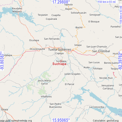
Suchiapa GPS coordinates[2]
16° 37' 31.98" North, 93° 6' 2.664" West
| Map corner | latitude | longitude |
|---|---|---|
| Upper-left | 17.29808°, | -93.80387° |
| Center: | 16.62555°, | -93.10074° |
| Lower-right: | 15.95065°, | -92.39762° |
| Map W x H: | 149.8×149.8 km | = 93.1×93.1mi |
| max Lat: | 32.7° ⇑93.4% North |
| Suchiapa: | 16.62555° |
| min Lat: | ⇓6.6% South 14.53588° |
| min Long | Suchiapa | max Long |
| -117.105° | -93.10074° | -86.73105° |
| W 88.1%⇐ | ⇒11.9% E |
Elevation
Elevation of Suchiapa is 464 m = 1522 ft, and this is 789.7 m = 2591 ft below average elevation for this country.
| Max E: |
3497 m = 11473 ft | 69.1% |
| Avg. | 1253.7 m = 4113 ft | |
| Suchiapa | 464 m = 1522 ft | |
Min E: |
-1 m = -3 ft | 30.9% |
See also: Mexico elevation on elevation.city.
Geographical zone
Suchiapa is located in North Torrid zone (between Equator and Tropic of Cancer). Distance of this Northern Tropic circle is 757.3 km =470.6 mi to North.| Distance of | km | miles | from Suchiapa |
|---|---|---|---|
| North Pole | 8158.5 | 5069.5 | to North |
| Arctic Circle | 5552.6 | 3450.2 | to North |
| Tropic Cancer | 757.3 | 470.6 | to North |
| Equator | 1848.6 | 1148.7 | to South |


Nearby cities:
15 places around Suchiapa: (largest is in red/bold)
• Amatal
11.2 km =7 mi,  83°
83°
• América Libre
11.7 km =7.3 mi,  95°
95°
• Copoya
9.8 km =6.1 mi,  347°
347°
• Cupasmí
11.4 km =7.1 mi,  61°
61°
• Distrito Federal
8.8 km =5.5 mi,  116°
116°
• El Jobo
8.7 km =5.4 mi,  356°
356°
• Francisco Sarabia
12.8 km =8 mi,  127°
127°
• Galecio Narcia
9.5 km =5.9 mi, 115°
• La Palma
12.2 km =7.6 mi,  187°
187°
• Las Flechas
11.5 km =7.1 mi,  43°
43°
• Narciso Mendoza
12.9 km =8 mi,  113°
113°
• Pacú
3.8 km =2.4 mi,  287°
287°
• Ribera Cupía (La Mesa)
10.1 km =6.3 mi, 61°
• Ribera la Unión (Castaño)
11.6 km =7.2 mi, 103°
• Salvador Urbina
10.5 km =6.5 mi, 84°
Sources, notices
• [Note1] Compared only with cities in Mexico existing in our database
• [Src1] Map data: © OpenStreetMap contributors (CC-BY-SA)
• [Src2] Other city data from geonames.org with taken over terms of usage.
• [Src3] Geographical zone / Annual Mean Temperature by Robert A. Rohde @ Wikipedia
