La Piedad geodata
La Piedad (Chiapas) is a populated place; located in Mexico in America/Mexico_City (GMT-6) time zone. With population of 683 people, there are 12712 cities with bigger population in this country. Compared to other cities in Mexico, 94.3% of cities are located further ↑North; 94.6% of cities are located further ←West and 69.3% of cities have lower elevation than La Piedad. Note1


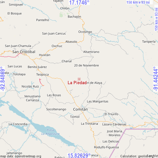
La Piedad GPS coordinates[2]
16° 30' 5.832" North, 92° 8' 44.016" West
| Map corner | latitude | longitude |
|---|---|---|
| Upper-left | 17.1746°, | -92.84869° |
| Center: | 16.50162°, | -92.14556° |
| Lower-right: | 15.82629°, | -91.44244° |
| Map W x H: | 149.9×149.9 km | = 93.1×93.1mi |
| max Lat: | 32.7° ⇑94.3% North |
| La Piedad: | 16.50162° |
| min Lat: | ⇓5.7% South 14.53588° |
| min Long | La Piedad | max Long |
| -117.105° | -92.14556° | -86.73105° |
| W 94.6%⇐ | ⇒5.4% E |
Elevation
Elevation of La Piedad is 1913 m = 6276 ft, and this is 659.3 m = 2163 ft above average elevation for this country.
| Max E: |
3497 m = 11473 ft | 30.7% |
| La Piedad | 1913 m 6276 ft | |
| Avg. | 1253.7 m = 4113 ft | |
Min E: |
-1 m = -3 ft | 69.3% |
See also: Mexico elevation on elevation.city.
Geographical zone
La Piedad is located in North Torrid zone (between Equator and Tropic of Cancer). Distance of this Northern Tropic circle is 771.1 km =479.1 mi to North.| Distance of | km | miles | from La Piedad |
|---|---|---|---|
| North Pole | 8172.3 | 5078 | to North |
| Arctic Circle | 5566.4 | 3458.8 | to North |
| Tropic Cancer | 771.1 | 479.1 | to North |
| Equator | 1834.8 | 1140.1 | to South |


Nearby cities:
15 places around La Piedad: (largest is in red/bold)
• Bajucu
9.1 km =5.7 mi,  108°
108°
• Buenavista Bawitz
3.4 km =2.1 mi,  90°
90°
• El Vergel
11 km =6.8 mi,  38°
38°
• González de León
9.5 km =5.9 mi, 87°
• Justo Sierra
10.4 km =6.5 mi,  64°
64°
• Juznajab la Laguna
14.2 km =8.8 mi,  160°
160°
• La Ilusión
13.5 km =8.4 mi, 37°
• Lomantán
11 km =6.8 mi,  128°
128°
• Nuevo México
9.9 km =6.2 mi, 40°
• Plan de Ayala
13 km =8.1 mi,  104°
104°
• Rosario Bawitz
5 km =3.1 mi, 99°
• San Antonio Bawitz
3.7 km =2.3 mi,  68°
68°
• Santa Rita Sonora
13.7 km =8.5 mi,  81°
81°
• Santa Rosalía
11.3 km =7 mi,  254°
254°
• Zaragoza la Montaña
11.4 km =7.1 mi,  213°
213°
Sources, notices
• [Note1] Compared only with cities in Mexico existing in our database
• [Src1] Map data: © OpenStreetMap contributors (CC-BY-SA)
• [Src2] Other city data from geonames.org with taken over terms of usage.
• [Src3] Geographical zone / Annual Mean Temperature by Robert A. Rohde @ Wikipedia
