Lomantán geodata
Lomantán (Chiapas) is a populated place; located in Mexico in America/Mexico_City (GMT-6) time zone. With population of 1,034 people, there are 8428 cities with bigger population in this country. Compared to other cities in Mexico, 94.7% of cities are located further ↑North; 95% of cities are located further ←West and 62.9% of cities have lower elevation than Lomantán. Note1


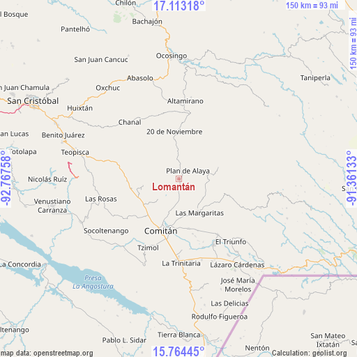
Lomantán GPS coordinates[2]
16° 26' 23.964" North, 92° 3' 52.02" West
| Map corner | latitude | longitude |
|---|---|---|
| Upper-left | 17.11318°, | -92.76758° |
| Center: | 16.43999°, | -92.06445° |
| Lower-right: | 15.76445°, | -91.36133° |
| Map W x H: | 150×150 km | = 93.2×93.2mi |
| max Lat: | 32.7° ⇑94.7% North |
| Lomantán: | 16.43999° |
| min Lat: | ⇓5.3% South 14.53588° |
| min Long | Lomantán | max Long |
| -117.105° | -92.06445° | -86.73105° |
| W 95%⇐ | ⇒5% E |
Elevation
Elevation of Lomantán is 1776 m = 5827 ft, and this is 522.3 m = 1714 ft above average elevation for this country.
| Max E: |
3497 m = 11473 ft | 37.1% |
| Lomantán | 1776 m 5827 ft | |
| Avg. | 1253.7 m = 4113 ft | |
Min E: |
-1 m = -3 ft | 62.9% |
See also: Mexico elevation on elevation.city.
Geographical zone
Lomantán is located in North Torrid zone (between Equator and Tropic of Cancer). Distance of this Northern Tropic circle is 778 km =483.4 mi to North.| Distance of | km | miles | from Lomantán |
|---|---|---|---|
| North Pole | 8179.1 | 5082.3 | to North |
| Arctic Circle | 5573.2 | 3463 | to North |
| Tropic Cancer | 778 | 483.4 | to North |
| Equator | 1828 | 1135.9 | to South |


Nearby cities:
15 places around Lomantán: (largest is in red/bold)
• Bajucu
3.9 km =2.4 mi,  359°
359°
• Buenavista Bawitz
8.6 km =5.3 mi,  322°
322°
• González de León
7.4 km =4.6 mi,  6°
6°
• Jalisco
9.6 km =6 mi,  96°
96°
• Justo Sierra
11.4 km =7.1 mi,  3°
3°
• Juznajab la Laguna
7.6 km =4.7 mi,  211°
211°
• La Piedad
11 km =6.8 mi,  308°
308°
• Mexiquito
10.9 km =6.8 mi,  73°
73°
• Plan de Ayala
5.3 km =3.3 mi,  48°
48°
• Rosario Bawitz
7.1 km =4.4 mi,  328°
328°
• San Antonio Bawitz
9.7 km =6 mi, 327°
• Santa Rita Sonora
10.1 km =6.3 mi,  29°
29°
• Veracruz
8 km =5 mi,  119°
119°
• Villahermosa Yaluma
11.9 km =7.4 mi,  186°
186°
• Yasha
5.4 km =3.4 mi,  184°
184°
Sources, notices
• [Note1] Compared only with cities in Mexico existing in our database
• [Src1] Map data: © OpenStreetMap contributors (CC-BY-SA)
• [Src2] Other city data from geonames.org with taken over terms of usage.
• [Src3] Geographical zone / Annual Mean Temperature by Robert A. Rohde @ Wikipedia
