Nuevo México geodata
Nuevo México (Chiapas) is a populated place; located in Mexico in America/Mexico_City (GMT-6) time zone. With population of 662 people, there are 13120 cities with bigger population in this country. Compared to other cities in Mexico, 93.9% of cities are located further ↑North; 94.9% of cities are located further ←West and 53.7% of cities have lower elevation than Nuevo México. Note1


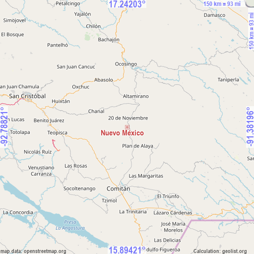
Nuevo México GPS coordinates[2]
16° 34' 9.48" North, 92° 5' 6.288" West
| Map corner | latitude | longitude |
|---|---|---|
| Upper-left | 17.24203°, | -92.78821° |
| Center: | 16.5693°, | -92.08508° |
| Lower-right: | 15.89421°, | -91.38196° |
| Map W x H: | 149.9×149.9 km | = 93.1×93.1mi |
| max Lat: | 32.7° ⇑93.9% North |
| Nuevo México: | 16.5693° |
| min Lat: | ⇓6.1% South 14.53588° |
| min Long | Nuevo México | max Long |
| -117.105° | -92.08508° | -86.73105° |
| W 94.9%⇐ | ⇒5.1% E |
Elevation
Elevation of Nuevo México is 1556 m = 5105 ft, and this is 302.3 m = 992 ft above average elevation for this country.
| Max E: |
3497 m = 11473 ft | 46.3% |
| Nuevo México | 1556 m 5105 ft | |
| Avg. | 1253.7 m = 4113 ft | |
Min E: |
-1 m = -3 ft | 53.7% |
See also: Mexico elevation on elevation.city.
Geographical zone
Nuevo México is located in North Torrid zone (between Equator and Tropic of Cancer). Distance of this Northern Tropic circle is 763.6 km =474.5 mi to North.| Distance of | km | miles | from Nuevo México |
|---|---|---|---|
| North Pole | 8164.7 | 5073.3 | to North |
| Arctic Circle | 5558.8 | 3454.1 | to North |
| Tropic Cancer | 763.6 | 474.5 | to North |
| Equator | 1842.3 | 1144.8 | to South |


Nearby cities:
15 places around Nuevo México: (largest is in red/bold)
• Bajucu
10.7 km =6.6 mi,  168°
168°
• Buenavista Bawitz
8.1 km =5 mi,  201°
201°
• El Vergel
1.2 km =0.7 mi,  18°
18°
• González de León
7.7 km =4.8 mi,  156°
156°
• Justo Sierra
4.2 km =2.6 mi,  135°
135°
• La Ilusión
3.7 km =2.3 mi,  28°
28°
• La Piedad
9.9 km =6.2 mi,  220°
220°
• Lomantán
14.5 km =9 mi, 171°
• Mexiquito
17 km =10.6 mi,  131°
131°
• Plan de Ayala
12.5 km =7.8 mi,  150°
150°
• Rosario Bawitz
8.5 km =5.3 mi,  190°
190°
• San Antonio Bawitz
6.9 km =4.3 mi,  206°
206°
• San Caralampio
12.5 km =7.8 mi,  92°
92°
• Santa Rita Sonora
9.1 km =5.7 mi, 127°
• Veinte de Noviembre
5.6 km =3.5 mi,  3°
3°
Sources, notices
• [Note1] Compared only with cities in Mexico existing in our database
• [Src1] Map data: © OpenStreetMap contributors (CC-BY-SA)
• [Src2] Other city data from geonames.org with taken over terms of usage.
• [Src3] Geographical zone / Annual Mean Temperature by Robert A. Rohde @ Wikipedia
