Vicente Guerrero geodata
Vicente Guerrero (Chiapas) is a populated place; located in Mexico in America/Mexico_City (GMT-6) time zone. With population of 621 people, there are 13905 cities with bigger population in this country. Compared to other cities in Mexico, 95.1% of cities are located further ↑North; 96% of cities are located further ←West and 58.7% of cities have higher elevation than Vicente Guerrero. Note1


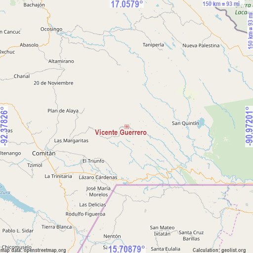
Vicente Guerrero GPS coordinates[2]
16° 23' 4.236" North, 91° 40' 30.468" West
| Map corner | latitude | longitude |
|---|---|---|
| Upper-left | 17.0579°, | -92.37826° |
| Center: | 16.38451°, | -91.67513° |
| Lower-right: | 15.70879°, | -90.97201° |
| Map W x H: | 150×150 km | = 93.2×93.2mi |
| max Lat: | 32.7° ⇑95.1% North |
| Vicente Guerrero: | 16.38451° |
| min Lat: | ⇓4.9% South 14.53588° |
| min Long | Vicente Guerrer | max Long |
| -117.105° | -91.67513° | -86.73105° |
| W 96%⇐ | ⇒4% E |
Elevation
Elevation of Vicente Guerrero is 1066 m = 3497 ft, and this is 187.7 m = 616 ft below average elevation for this country.
| Max E: |
3497 m = 11473 ft | 58.7% |
| Avg. | 1253.7 m = 4113 ft | |
| Vicente Guerrero | 1066 m = 3497 ft | |
Min E: |
-1 m = -3 ft | 41.3% |
See also: Mexico elevation on elevation.city.
Geographical zone
Vicente Guerrero is located in North Torrid zone (between Equator and Tropic of Cancer). Distance of this Northern Tropic circle is 784.1 km =487.2 mi to North.| Distance of | km | miles | from Vicente Guerrero |
|---|---|---|---|
| North Pole | 8185.3 | 5086.1 | to North |
| Arctic Circle | 5579.4 | 3466.9 | to North |
| Tropic Cancer | 784.1 | 487.2 | to North |
| Equator | 1821.8 | 1132 | to South |


Nearby cities:
15 places around Vicente Guerrero: (largest is in red/bold)
• Buenavista Pachán
15.4 km =9.6 mi,  239°
239°
• El Edén
11 km =6.8 mi,  158°
158°
• El Paraíso
13.9 km =8.6 mi,  210°
210°
• Nuevo Momón
9.5 km =5.9 mi,  230°
230°
• Plan de Santo Tomás
10.4 km =6.5 mi,  71°
71°
• Río Corozal
15 km =9.3 mi,  37°
37°
• San Agustín
18.2 km =11.3 mi,  154°
154°
• San Antonio Porvenir
17.9 km =11.1 mi,  185°
185°
• San Isidro
7.1 km =4.4 mi, 148°
• San Juan Bautista
9.6 km =6 mi,  24°
24°
• San Juan del Pozo
6 km =3.7 mi,  320°
320°
• Santa Elena
18.9 km =11.7 mi,  216°
216°
• Santa Lucía Ojo de Agua
11.6 km =7.2 mi,  87°
87°
• Santa Rita Invernadero
16 km =9.9 mi,  78°
78°
• Santa Rita el Vergel
15.4 km =9.6 mi,  200°
200°
Sources, notices
• [Note1] Compared only with cities in Mexico existing in our database
• [Src1] Map data: © OpenStreetMap contributors (CC-BY-SA)
• [Src2] Other city data from geonames.org with taken over terms of usage.
• [Src3] Geographical zone / Annual Mean Temperature by Robert A. Rohde @ Wikipedia
