San Antonio Porvenir geodata
San Antonio Porvenir (Chiapas) is a populated place; located in Mexico in America/Mexico_City (GMT-6) time zone. With population of 525 people, there are 16085 cities with bigger population in this country. Compared to other cities in Mexico, 96.2% of cities are located further ↑North; 96% of cities are located further ←West and 52.5% of cities have higher elevation than San Antonio Porvenir. Note1
Current local time in San Antonio Porvenir:
08:05 AM, WednesdayDifference from your time zone: hours


San Antonio Porvenir GPS coordinates[2]
16° 13' 26.004" North, 91° 41' 26.988" West
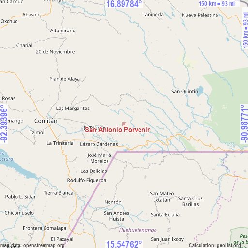
| Map corner | latitude | longitude |
|---|---|---|
| Upper-left | 16.89784°, | -92.39396° |
| Center: | 16.22389°, | -91.69083° |
| Lower-right: | 15.54762°, | -90.98771° |
| Map W x H: | 150.1×150.1 km | = 93.3×93.3mi |
| max Lat: | 32.7° ⇑96.2% North |
| San Antonio Porvenir: | 16.22389° |
| min Lat: | ⇓3.8% South 14.53588° |
| min Long | San Antonio Por | max Long |
| -117.105° | -91.69083° | -86.73105° |
| W 96%⇐ | ⇒4% E |
Elevation
Elevation of San Antonio Porvenir is 1315 m = 4314 ft, and this is 61.3 m = 201 ft above average elevation for this country.
| Max E: |
3497 m = 11473 ft | 52.5% |
| San Antonio Porvenir | 1315 m 4314 ft | |
| Avg. | 1253.7 m = 4113 ft | |
Min E: |
-1 m = -3 ft | 47.5% |
See also: Mexico elevation on elevation.city.
Geographical zone
San Antonio Porvenir is located in North Torrid zone (between Equator and Tropic of Cancer). Distance of this Northern Tropic circle is 802 km =498.3 mi to North.| Distance of | km | miles | from San Antonio Porvenir |
|---|---|---|---|
| North Pole | 8203.1 | 5097.2 | to North |
| Arctic Circle | 5597.2 | 3477.9 | to North |
| Tropic Cancer | 802 | 498.3 | to North |
| Equator | 1803.9 | 1120.9 | to South |


Nearby cities:
15 places around San Antonio Porvenir: (largest is in red/bold)
• Buenavista Pachán
15.3 km =9.5 mi,  310°
310°
• Cuauhtémoc
14.9 km =9.3 mi,  148°
148°
• El Edén
9.5 km =5.9 mi,  36°
36°
• El Paraíso
8 km =5 mi,  317°
317°
• Nuevo Momón
13 km =8.1 mi,  334°
334°
• Ojo de Agua
10.3 km =6.4 mi,  224°
224°
• Playa Azul
10 km =6.2 mi,  117°
117°
• Río Blanco
6.4 km =4 mi,  109°
109°
• San Agustín
9.6 km =6 mi,  81°
81°
• San Antonio Buenavista
9.1 km =5.7 mi, 151°
• San Isidro
12.9 km =8 mi,  24°
24°
• San Isidro el Zapotal
11 km =6.8 mi,  131°
131°
• Santa Elena
9.9 km =6.2 mi,  285°
285°
• Santa Rita el Vergel
5.1 km =3.2 mi, 312°
• Tierra y Libertad
7.2 km =4.5 mi,  141°
141°
Sources, notices
• [Note1] Compared only with cities in Mexico existing in our database
• [Src1] Map data: © OpenStreetMap contributors (CC-BY-SA)
• [Src2] Other city data from geonames.org with taken over terms of usage.
• [Src3] Geographical zone / Annual Mean Temperature by Robert A. Rohde @ Wikipedia
