San Isidro geodata
San Isidro (Chiapas) is a populated place; located in Mexico in America/Mexico_City (GMT-6) time zone. With population of 711 people, there are 12248 cities with bigger population in this country. Compared to other cities in Mexico, 95.5% of cities are located further ↑North; 96% of cities are located further ←West and 57.6% of cities have higher elevation than San Isidro. Note1


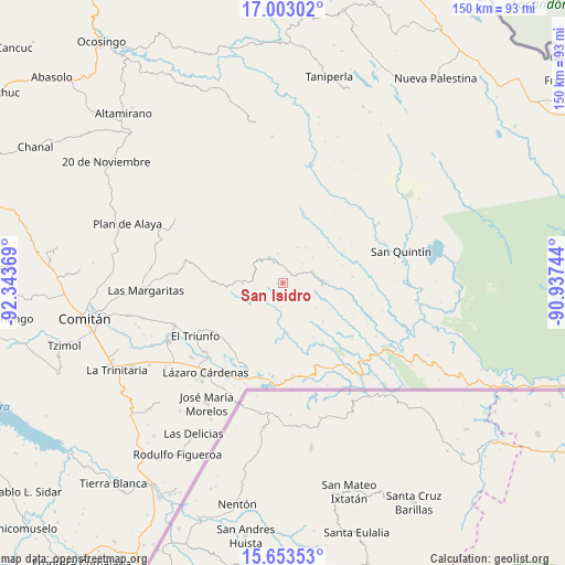
San Isidro GPS coordinates[2]
16° 19' 45.984" North, 91° 38' 26.016" West
| Map corner | latitude | longitude |
|---|---|---|
| Upper-left | 17.00302°, | -92.34369° |
| Center: | 16.32944°, | -91.64056° |
| Lower-right: | 15.65353°, | -90.93744° |
| Map W x H: | 150×150.1 km | = 93.2×93.3mi |
| max Lat: | 32.7° ⇑95.5% North |
| San Isidro: | 16.32944° |
| min Lat: | ⇓4.5% South 14.53588° |
| min Long | San Isidro | max Long |
| -117.105° | -91.64056° | -86.73105° |
| W 96%⇐ | ⇒4% E |
Elevation
Elevation of San Isidro is 1111 m = 3645 ft, and this is 142.7 m = 468 ft below average elevation for this country.
| Max E: |
3497 m = 11473 ft | 57.6% |
| Avg. | 1253.7 m = 4113 ft | |
| San Isidro | 1111 m = 3645 ft | |
Min E: |
-1 m = -3 ft | 42.4% |
See also: Mexico elevation on elevation.city.
Geographical zone
San Isidro is located in North Torrid zone (between Equator and Tropic of Cancer). Distance of this Northern Tropic circle is 790.3 km =491.1 mi to North.| Distance of | km | miles | from San Isidro |
|---|---|---|---|
| North Pole | 8191.4 | 5089.9 | to North |
| Arctic Circle | 5585.5 | 3470.7 | to North |
| Tropic Cancer | 790.3 | 491.1 | to North |
| Equator | 1815.7 | 1128.2 | to South |


Nearby cities:
15 places around San Isidro: (largest is in red/bold)
• Buenavista Pachán
17 km =10.6 mi,  264°
264°
• El Edén
4.2 km =2.6 mi,  175°
175°
• El Paraíso
12.3 km =7.6 mi,  241°
241°
• Nuevo Momón
11 km =6.8 mi,  270°
270°
• Plan de Santo Tomás
11.2 km =7 mi,  33°
33°
• Playa Azul
16.7 km =10.4 mi,  168°
168°
• Río Blanco
13.9 km =8.6 mi, 177°
• San Agustín
11.1 km =6.9 mi,  158°
158°
• San Antonio Porvenir
12.9 km =8 mi,  204°
204°
• San Juan Bautista
14.8 km =9.2 mi,  1°
1°
• San Juan del Pozo
13.1 km =8.1 mi,  324°
324°
• Santa Lucía Ojo de Agua
10.3 km =6.4 mi,  49°
49°
• Santa Rita Invernadero
15.2 km =9.4 mi, 52°
• Santa Rita el Vergel
12.4 km =7.7 mi,  227°
227°
• Vicente Guerrero
7.1 km =4.4 mi,  328°
328°
Sources, notices
• [Note1] Compared only with cities in Mexico existing in our database
• [Src1] Map data: © OpenStreetMap contributors (CC-BY-SA)
• [Src2] Other city data from geonames.org with taken over terms of usage.
• [Src3] Geographical zone / Annual Mean Temperature by Robert A. Rohde @ Wikipedia
