San Nicolás geodata
San Nicolás (State of Mexico) is a populated place; located in Mexico in America/Mexico_City (GMT-6) time zone. With population of 1,594 people, there are 5418 cities with bigger population in this country. Compared to other cities in Mexico, 66.2% of cities are located further ↑North; 57.9% of cities are located further →East and 76.2% of cities have lower elevation than San Nicolás. Note1


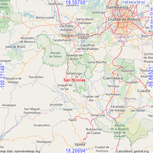
San Nicolás GPS coordinates[2]
18° 55' 59.988" North, 99° 34' 5.988" West
| Map corner | latitude | longitude |
|---|---|---|
| Upper-left | 19.59708°, | -100.27146° |
| Center: | 18.93333°, | -99.56833° |
| Lower-right: | 18.26694°, | -98.86521° |
| Map W x H: | 147.9×147.9 km | = 91.9×91.9mi |
| max Lat: | 32.7° ⇑66.2% North |
| San Nicolás: | 18.93333° |
| min Lat: | ⇓33.8% South 14.53588° |
| min Long | San Nicolás | max Long |
| -117.105° | -99.56833° | -86.73105° |
| W 42.1%⇐ | ⇒57.9% E |
Elevation
Elevation of San Nicolás is 2051 m = 6729 ft, and this is 797.3 m = 2616 ft above average elevation for this country.
| Max E: |
3497 m = 11473 ft | 23.8% |
| San Nicolás | 2051 m 6729 ft | |
| Avg. | 1253.7 m = 4113 ft | |
Min E: |
-1 m = -3 ft | 76.2% |
See also: Mexico elevation on elevation.city.
Geographical zone
San Nicolás is located in North Torrid zone (between Equator and Tropic of Cancer). Distance of this Northern Tropic circle is 500.7 km =311.1 mi to North.| Distance of | km | miles | from San Nicolás |
|---|---|---|---|
| North Pole | 7901.9 | 4910 | to North |
| Arctic Circle | 5296 | 3290.8 | to North |
| Tropic Cancer | 500.7 | 311.1 | to North |
| Equator | 2105.2 | 1308.1 | to South |


Nearby cities:
15 places around San Nicolás: (largest is in red/bold)
• Acatzingo (Acatzingo de la Piedra)
2.4 km =1.5 mi,  243°
243°
• Colonia Emiliano Zapata Ejido de Tenancingo
2.5 km =1.6 mi,  23°
23°
• Ejido Ixpuchiapan
1.6 km =1 mi,  341°
341°
• Ejido de Tenería (El Llano)
2.7 km =1.7 mi,  4°
4°
• El Carmen (El Desierto del Carmen)
1.9 km =1.2 mi,  139°
139°
• El Salitre
3.1 km =1.9 mi,  313°
313°
• Ixpuichiapan
2 km =1.2 mi,  268°
268°
• La Ciénega
2.9 km =1.8 mi,  331°
331°
• Pueblo Nuevo
2.3 km =1.4 mi, 314°
• Quetzalapa
3.1 km =1.9 mi,  284°
284°
• San José Tenería (Tenería)
3.3 km =2.1 mi,  54°
54°
• San José el Cuartel
3.1 km =1.9 mi, 342°
• Tepalcatepec
3.3 km =2.1 mi, 274°
• Terrenate
2.7 km =1.7 mi,  256°
256°
• Zumpahuacán
1.9 km =1.2 mi,  171°
171°
Sources, notices
• [Note1] Compared only with cities in Mexico existing in our database
• [Src1] Map data: © OpenStreetMap contributors (CC-BY-SA)
• [Src2] Other city data from geonames.org with taken over terms of usage.
• [Src3] Geographical zone / Annual Mean Temperature by Robert A. Rohde @ Wikipedia
