Terrenate geodata
Terrenate (State of Mexico) is a populated place; located in Mexico in America/Mexico_City (GMT-6) time zone. With population of 527 people, there are 16037 cities with bigger population in this country. Compared to other cities in Mexico, 66.4% of cities are located further ↑North; 58.4% of cities are located further →East and 79.7% of cities have lower elevation than Terrenate. Note1


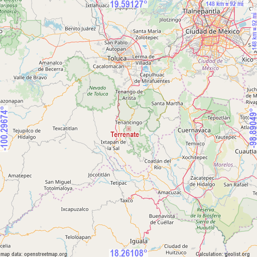
Terrenate GPS coordinates[2]
18° 55' 39" North, 99° 35' 36.996" West
| Map corner | latitude | longitude |
|---|---|---|
| Upper-left | 19.59127°, | -100.29674° |
| Center: | 18.9275°, | -99.59361° |
| Lower-right: | 18.26108°, | -98.89049° |
| Map W x H: | 147.9×147.9 km | = 91.9×91.9mi |
| max Lat: | 32.7° ⇑66.4% North |
| Terrenate: | 18.9275° |
| min Lat: | ⇓33.6% South 14.53588° |
| min Long | Terrenate | max Long |
| -117.105° | -99.59361° | -86.73105° |
| W 41.6%⇐ | ⇒58.4% E |
Elevation
Elevation of Terrenate is 2133 m = 6998 ft, and this is 879.3 m = 2885 ft above average elevation for this country.
| Max E: |
3497 m = 11473 ft | 20.3% |
| Terrenate | 2133 m 6998 ft | |
| Avg. | 1253.7 m = 4113 ft | |
Min E: |
-1 m = -3 ft | 79.7% |
See also: Mexico elevation on elevation.city.
Geographical zone
Terrenate is located in North Torrid zone (between Equator and Tropic of Cancer). Distance of this Northern Tropic circle is 501.4 km =311.6 mi to North.| Distance of | km | miles | from Terrenate |
|---|---|---|---|
| North Pole | 7902.5 | 4910.4 | to North |
| Arctic Circle | 5296.6 | 3291.2 | to North |
| Tropic Cancer | 501.4 | 311.6 | to North |
| Equator | 2104.5 | 1307.7 | to South |


Nearby cities:
15 places around Terrenate: (largest is in red/bold)
• Acatzingo (Acatzingo de la Piedra)
0.7 km =0.4 mi,  127°
127°
• Ejido Ixpuchiapan
3.1 km =1.9 mi,  44°
44°
• El Salitre
2.8 km =1.7 mi,  8°
8°
• Ixpuichiapan
0.9 km =0.6 mi,  49°
49°
• La Ciénega
3.4 km =2.1 mi,  21°
21°
• La Lagunilla
2.5 km =1.6 mi,  269°
269°
• Pueblo Nuevo
2.5 km =1.6 mi, 23°
• Quetzalapa
1.5 km =0.9 mi,  346°
346°
• San Antonio Guadalupe
2.9 km =1.8 mi,  203°
203°
• San José el Cuartel
4 km =2.5 mi,  25°
25°
• San Nicolás
2.7 km =1.7 mi,  76°
76°
• Tenancingo de Degollado
3.8 km =2.4 mi, 5°
• Tepalcatepec
1.1 km =0.7 mi,  326°
326°
• Tepetzingo
2.3 km =1.4 mi,  300°
300°
• Zumpahuacán
3.2 km =2 mi,  112°
112°
Sources, notices
• [Note1] Compared only with cities in Mexico existing in our database
• [Src1] Map data: © OpenStreetMap contributors (CC-BY-SA)
• [Src2] Other city data from geonames.org with taken over terms of usage.
• [Src3] Geographical zone / Annual Mean Temperature by Robert A. Rohde @ Wikipedia
