Tepoxtepec geodata
Tepoxtepec (State of Mexico) is a populated place; located in Mexico in America/Mexico_City (GMT-6) time zone. With population of 1,539 people, there are 5613 cities with bigger population in this country. Compared to other cities in Mexico, 65.5% of cities are located further ↑North; 57.7% of cities are located further →East and 76.2% of cities have lower elevation than Tepoxtepec. Note1


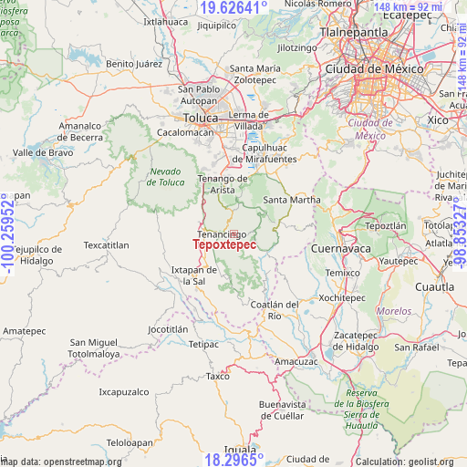
Tepoxtepec GPS coordinates[2]
18° 57' 46.008" North, 99° 33' 23.004" West
| Map corner | latitude | longitude |
|---|---|---|
| Upper-left | 19.62641°, | -100.25952° |
| Center: | 18.96278°, | -99.55639° |
| Lower-right: | 18.2965°, | -98.85327° |
| Map W x H: | 147.9×147.9 km | = 91.9×91.9mi |
| max Lat: | 32.7° ⇑65.5% North |
| Tepoxtepec: | 18.96278° |
| min Lat: | ⇓34.5% South 14.53588° |
| min Long | Tepoxtepec | max Long |
| -117.105° | -99.55639° | -86.73105° |
| W 42.3%⇐ | ⇒57.7% E |
Elevation
Elevation of Tepoxtepec is 2052 m = 6732 ft, and this is 798.3 m = 2619 ft above average elevation for this country.
| Max E: |
3497 m = 11473 ft | 23.8% |
| Tepoxtepec | 2052 m 6732 ft | |
| Avg. | 1253.7 m = 4113 ft | |
Min E: |
-1 m = -3 ft | 76.2% |
See also: Mexico elevation on elevation.city.
Geographical zone
Tepoxtepec is located in North Torrid zone (between Equator and Tropic of Cancer). Distance of this Northern Tropic circle is 497.5 km =309.1 mi to North.| Distance of | km | miles | from Tepoxtepec |
|---|---|---|---|
| North Pole | 7898.6 | 4908 | to North |
| Arctic Circle | 5292.7 | 3288.7 | to North |
| Tropic Cancer | 497.5 | 309.1 | to North |
| Equator | 2108.5 | 1310.2 | to South |


Nearby cities:
15 places around Tepoxtepec: (largest is in red/bold)
• Chalchihuapan
2.5 km =1.6 mi,  309°
309°
• Colonia Emiliano Zapata Ejido de Tenancingo
1.1 km =0.7 mi,  194°
194°
• Colonia San Ramón
1.8 km =1.1 mi,  290°
290°
• Ejido Ixpuchiapan
2.5 km =1.6 mi,  225°
225°
• Ejido de Tenería (El Llano)
1.2 km =0.7 mi,  239°
239°
• La Ciénega
2.7 km =1.7 mi,  254°
254°
• La Mesita
3.4 km =2.1 mi, 310°
• La Trinidad
2.6 km =1.6 mi,  278°
278°
• Pueblo Nuevo
3.3 km =2.1 mi, 240°
• San Diego
3.2 km =2 mi, 290°
• San José Tenería (Tenería)
2 km =1.2 mi,  134°
134°
• San José el Cuartel
2.2 km =1.4 mi,  261°
261°
• San Juan Tetitlán
1.8 km =1.1 mi, 307°
• San Miguel Tecomatlán
3.4 km =2.1 mi,  59°
59°
• San Nicolás
3.5 km =2.2 mi,  200°
200°
Sources, notices
• [Note1] Compared only with cities in Mexico existing in our database
• [Src1] Map data: © OpenStreetMap contributors (CC-BY-SA)
• [Src2] Other city data from geonames.org with taken over terms of usage.
• [Src3] Geographical zone / Annual Mean Temperature by Robert A. Rohde @ Wikipedia
