Guadalupe Relinas geodata
Guadalupe Relinas (Hidalgo) is a populated place; located in Mexico in America/Mexico_City (GMT-6) time zone. With population of 731 people, there are 11944 cities with bigger population in this country. Compared to other cities in Mexico, 54.6% of cities are located further ↓South; 54% of cities are located further ←West and 88.9% of cities have lower elevation than Guadalupe Relinas. Note1


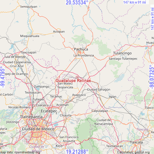
Guadalupe Relinas GPS coordinates[2]
19° 52' 31.764" North, 98° 46' 34.932" West
| Map corner | latitude | longitude |
|---|---|---|
| Upper-left | 20.53534°, | -99.4795° |
| Center: | 19.87549°, | -98.77637° |
| Lower-right: | 19.21288°, | -98.07325° |
| Map W x H: | 147×147 km | = 91.3×91.3mi |
| max Lat: | 32.7° ⇑45.4% North |
| Guadalupe Relinas: | 19.87549° |
| min Lat: | ⇓54.6% South 14.53588° |
| min Long | Guadalupe Relin | max Long |
| -117.105° | -98.77637° | -86.73105° |
| W 54%⇐ | ⇒46% E |
Elevation
Elevation of Guadalupe Relinas is 2367 m = 7766 ft, and this is 1113.3 m = 3653 ft above average elevation for this country.
| Max E: |
3497 m = 11473 ft | 11.1% |
| Guadalupe Relinas | 2367 m 7766 ft | |
| Avg. | 1253.7 m = 4113 ft | |
Min E: |
-1 m = -3 ft | 88.9% |
See also: Mexico elevation on elevation.city.
Geographical zone
Guadalupe Relinas is located in North Torrid zone (between Equator and Tropic of Cancer). Distance of this Northern Tropic circle is 396 km =246.1 mi to North.| Distance of | km | miles | from Guadalupe Relinas |
|---|---|---|---|
| North Pole | 7797.1 | 4844.9 | to North |
| Arctic Circle | 5191.2 | 3225.7 | to North |
| Tropic Cancer | 396 | 246.1 | to North |
| Equator | 2209.9 | 1373.2 | to South |


Nearby cities:
15 places around Guadalupe Relinas: (largest is in red/bold)
• Barrio de Belén
8.6 km =5.3 mi,  247°
247°
• Colonia Benito Juárez
3.5 km =2.2 mi,  296°
296°
• Colonia Guadalupe
7.2 km =4.5 mi,  9°
9°
• Colonia Morelos
4.5 km =2.8 mi,  291°
291°
• Ixtlahuaca de Cuauhtémoc
8.8 km =5.5 mi,  274°
274°
• San Agustín Zapotlán
6.5 km =4 mi,  89°
89°
• San Antonio Coayuca
3.8 km =2.4 mi,  228°
228°
• San Felipe Teotitlán
11.2 km =7 mi,  135°
135°
• San Felipe Zacatepec
3.8 km =2.4 mi,  193°
193°
• San Pablo Xúchil
7.7 km =4.8 mi,  170°
170°
• San Pedro Tlaquilpan
8.1 km =5 mi,  17°
17°
• Santa María Actipac
3.9 km =2.4 mi,  124°
124°
• Santo Domingo Aztacameca
10.4 km =6.5 mi,  175°
175°
• Teacalco
11.1 km =6.9 mi, 225°
• Tezontepec
4.6 km =2.9 mi,  277°
277°
Sources, notices
• [Note1] Compared only with cities in Mexico existing in our database
• [Src1] Map data: © OpenStreetMap contributors (CC-BY-SA)
• [Src2] Other city data from geonames.org with taken over terms of usage.
• [Src3] Geographical zone / Annual Mean Temperature by Robert A. Rohde @ Wikipedia
