Celayita geodata
Celayita (State of Mexico) is a populated place; located in Mexico in America/Mexico_City (GMT-6) time zone. With population of 1,119 people, there are 7761 cities with bigger population in this country. Compared to other cities in Mexico, 62.3% of cities are located further ↓South; 62.3% of cities are located further →East and 85.7% of cities have lower elevation than Celayita. Note1


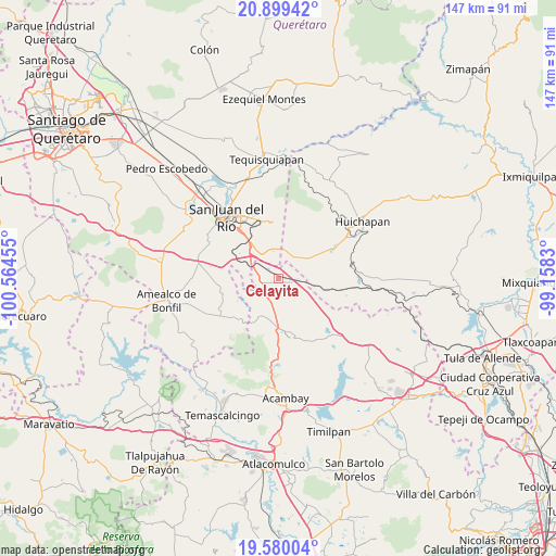
Celayita GPS coordinates[2]
20° 14' 28.068" North, 99° 51' 41.112" West
| Map corner | latitude | longitude |
|---|---|---|
| Upper-left | 20.89942°, | -100.56455° |
| Center: | 20.24113°, | -99.86142° |
| Lower-right: | 19.58004°, | -99.1583° |
| Map W x H: | 146.7×146.7 km | = 91.2×91.2mi |
| max Lat: | 32.7° ⇑37.7% North |
| Celayita: | 20.24113° |
| min Lat: | ⇓62.3% South 14.53588° |
| min Long | Celayita | max Long |
| -117.105° | -99.86142° | -86.73105° |
| W 37.7%⇐ | ⇒62.3% E |
Elevation
Elevation of Celayita is 2275 m = 7464 ft, and this is 1021.3 m = 3351 ft above average elevation for this country.
| Max E: |
3497 m = 11473 ft | 14.3% |
| Celayita | 2275 m 7464 ft | |
| Avg. | 1253.7 m = 4113 ft | |
Min E: |
-1 m = -3 ft | 85.7% |
See also: Mexico elevation on elevation.city.
Geographical zone
Celayita is located in North Torrid zone (between Equator and Tropic of Cancer). Distance of this Northern Tropic circle is 355.3 km =220.8 mi to North.| Distance of | km | miles | from Celayita |
|---|---|---|---|
| North Pole | 7756.5 | 4819.7 | to North |
| Arctic Circle | 5150.6 | 3200.4 | to North |
| Tropic Cancer | 355.3 | 220.8 | to North |
| Equator | 2250.6 | 1398.5 | to South |


Nearby cities:
15 places around Celayita: (largest is in red/bold)
• Barrio Lázaro Cárdenas (San Rafael)
2.8 km =1.7 mi,  72°
72°
• Bañe
5.4 km =3.4 mi,  158°
158°
• El Carmen
8.2 km =5.1 mi,  30°
30°
• El Cazadero
6.6 km =4.1 mi,  350°
350°
• El Mogote
10 km =6.2 mi,  213°
213°
• El Tesoro
1.5 km =0.9 mi,  316°
316°
• El Álamo
7.9 km =4.9 mi,  117°
117°
• La Presita Segundo Cuartel
8.8 km =5.5 mi,  187°
187°
• La Purísima (Buenavista)
5.2 km =3.2 mi,  88°
88°
• Polotitlán de la Ilustración
5.1 km =3.2 mi,  110°
110°
• Puerta de Palmillas
9.7 km =6 mi, 324°
• San Antonio el Viejo
5.4 km =3.4 mi,  129°
129°
• San Lorenzo El Chico
9.8 km =6.1 mi,  78°
78°
• San Lucas Totolmaloya
9.4 km =5.8 mi,  203°
203°
• San Sebastián de Las Barrancas Sur
8.3 km =5.2 mi,  289°
289°
Sources, notices
• [Note1] Compared only with cities in Mexico existing in our database
• [Src1] Map data: © OpenStreetMap contributors (CC-BY-SA)
• [Src2] Other city data from geonames.org with taken over terms of usage.
• [Src3] Geographical zone / Annual Mean Temperature by Robert A. Rohde @ Wikipedia
