San Lucas Totolmaloya geodata
San Lucas Totolmaloya (State of Mexico) is a populated place; located in Mexico in America/Mexico_City (GMT-6) time zone. With population of 3,770 people, there are 2431 cities with bigger population in this country. Compared to other cities in Mexico, 60.5% of cities are located further ↓South; 62.6% of cities are located further →East and 89.2% of cities have lower elevation than San Lucas Totolmaloya. Note1


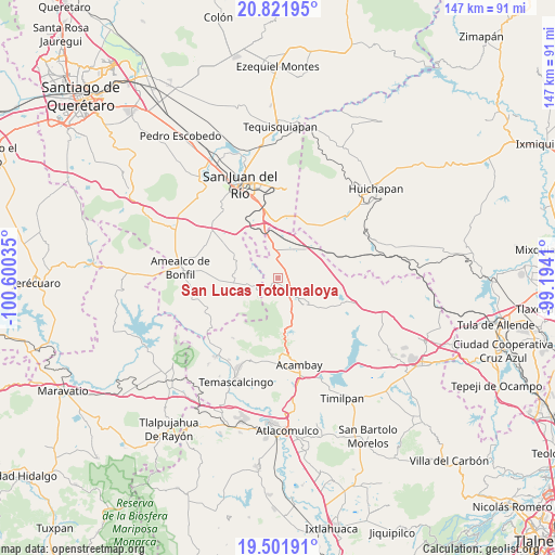
San Lucas Totolmaloya GPS coordinates[2]
20° 9' 47.988" North, 99° 53' 49.992" West
| Map corner | latitude | longitude |
|---|---|---|
| Upper-left | 20.82195°, | -100.60035° |
| Center: | 20.16333°, | -99.89722° |
| Lower-right: | 19.50191°, | -99.1941° |
| Map W x H: | 146.8×146.8 km | = 91.2×91.2mi |
| max Lat: | 32.7° ⇑39.5% North |
| San Lucas Totolmaloya: | 20.16333° |
| min Lat: | ⇓60.5% South 14.53588° |
| min Long | San Lucas Totol | max Long |
| -117.105° | -99.89722° | -86.73105° |
| W 37.4%⇐ | ⇒62.6% E |
Elevation
Elevation of San Lucas Totolmaloya is 2378 m = 7802 ft, and this is 1124.3 m = 3689 ft above average elevation for this country.
| Max E: |
3497 m = 11473 ft | 10.8% |
| San Lucas Totolmaloya | 2378 m 7802 ft | |
| Avg. | 1253.7 m = 4113 ft | |
Min E: |
-1 m = -3 ft | 89.2% |
See also: Mexico elevation on elevation.city.
Geographical zone
San Lucas Totolmaloya is located in North Torrid zone (between Equator and Tropic of Cancer). Distance of this Northern Tropic circle is 364 km =226.2 mi to North.| Distance of | km | miles | from San Lucas Totolmaloya |
|---|---|---|---|
| North Pole | 7765.1 | 4825 | to North |
| Arctic Circle | 5159.2 | 3205.8 | to North |
| Tropic Cancer | 364 | 226.2 | to North |
| Equator | 2242 | 1393.1 | to South |


Nearby cities:
15 places around San Lucas Totolmaloya: (largest is in red/bold)
• Bañe
6.7 km =4.2 mi,  57°
57°
• Celayita
9.4 km =5.8 mi,  23°
23°
• El Mogote
1.8 km =1.1 mi,  278°
278°
• Gunyo Oriente
10 km =6.2 mi,  120°
120°
• Gunyo Poniente (San José Gunyo)
8.4 km =5.2 mi,  133°
133°
• La Concepción Ejido
4.2 km =2.6 mi,  143°
143°
• La Concepción Pueblo
3.4 km =2.1 mi,  237°
237°
• La Presita Segundo Cuartel
2.6 km =1.6 mi,  91°
91°
• La Soledad Ejido
9.6 km =6 mi,  152°
152°
• San Antonio Pueblo
5.6 km =3.5 mi,  203°
203°
• San Antonio el Viejo
9.5 km =5.9 mi, 56°
• San Ildefonso Tultepec
6.8 km =4.2 mi,  251°
251°
• San Pedro Denxhi Segundo Cuartel
9.6 km =6 mi,  316°
316°
• Tenasdá (Barrio de San Ildefonso)
9.2 km =5.7 mi,  233°
233°
• Yosphí
5.8 km =3.6 mi, 278°
Sources, notices
• [Note1] Compared only with cities in Mexico existing in our database
• [Src1] Map data: © OpenStreetMap contributors (CC-BY-SA)
• [Src2] Other city data from geonames.org with taken over terms of usage.
• [Src3] Geographical zone / Annual Mean Temperature by Robert A. Rohde @ Wikipedia
