Boshindó geodata
Boshindó (State of Mexico) is a populated place; located in Mexico in America/Mexico_City (GMT-6) time zone. With population of 1,153 people, there are 7515 cities with bigger population in this country. Compared to other cities in Mexico, 55.5% of cities are located further ↓South; 62% of cities are located further →East and 94% of cities have lower elevation than Boshindó. Note1


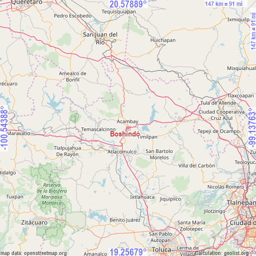
Boshindó GPS coordinates[2]
19° 55' 9.192" North, 99° 50' 26.7" West
| Map corner | latitude | longitude |
|---|---|---|
| Upper-left | 20.57889°, | -100.54388° |
| Center: | 19.91922°, | -99.84075° |
| Lower-right: | 19.25679°, | -99.13763° |
| Map W x H: | 147×147 km | = 91.3×91.3mi |
| max Lat: | 32.7° ⇑44.5% North |
| Boshindó: | 19.91922° |
| min Lat: | ⇓55.5% South 14.53588° |
| min Long | Boshindó | max Long |
| -117.105° | -99.84075° | -86.73105° |
| W 38%⇐ | ⇒62% E |
Elevation
Elevation of Boshindó is 2574 m = 8445 ft, and this is 1320.3 m = 4332 ft above average elevation for this country.
| Max E: |
3497 m = 11473 ft | 6% |
| Boshindó | 2574 m 8445 ft | |
| Avg. | 1253.7 m = 4113 ft | |
Min E: |
-1 m = -3 ft | 94% |
See also: Mexico elevation on elevation.city.
Geographical zone
Boshindó is located in North Torrid zone (between Equator and Tropic of Cancer). Distance of this Northern Tropic circle is 391.1 km =243 mi to North.| Distance of | km | miles | from Boshindó |
|---|---|---|---|
| North Pole | 7792.3 | 4841.9 | to North |
| Arctic Circle | 5186.4 | 3222.7 | to North |
| Tropic Cancer | 391.1 | 243 | to North |
| Equator | 2214.8 | 1376.2 | to South |


Nearby cities:
15 places around Boshindó: (largest is in red/bold)
• Acambay
4 km =2.5 mi,  354°
354°
• Botidi
5.2 km =3.2 mi,  357°
357°
• Detiña (San Antonio Detiña)
7.3 km =4.5 mi,  321°
321°
• Endeje
4.6 km =2.9 mi,  5°
5°
• La Caridad
3.2 km =2 mi, 7°
• La Loma de San Mateo
7.4 km =4.6 mi,  260°
260°
• La Soledad
6.8 km =4.2 mi,  273°
273°
• La Venta (Barrio la Venta)
6.7 km =4.2 mi,  86°
86°
• Pathé
0.9 km =0.6 mi, 8°
• San Ildefonso (San Ildefonso Yolotepec)
2 km =1.2 mi, 8°
• San Juanico Sector Dos
6.2 km =3.9 mi,  69°
69°
• San Mateo el Viejo
7.3 km =4.5 mi, 265°
• San Pedro de los Metates
2.9 km =1.8 mi,  219°
219°
• Santa Lucía (Ejido de San Mateo el Viejo)
7.4 km =4.6 mi,  250°
250°
• Tierras Blancas
5.9 km =3.7 mi,  201°
201°
Sources, notices
• [Note1] Compared only with cities in Mexico existing in our database
• [Src1] Map data: © OpenStreetMap contributors (CC-BY-SA)
• [Src2] Other city data from geonames.org with taken over terms of usage.
• [Src3] Geographical zone / Annual Mean Temperature by Robert A. Rohde @ Wikipedia
