Botidi geodata
Botidi (State of Mexico) is a populated place; located in Mexico in America/Mexico_City (GMT-6) time zone. With population of 615 people, there are 14017 cities with bigger population in this country. Compared to other cities in Mexico, 56.3% of cities are located further ↓South; 62.1% of cities are located further →East and 97% of cities have lower elevation than Botidi. Note1


Botidi GPS coordinates[2]
19° 57' 59.004" North, 99° 50' 34.008" West
| Map corner | latitude | longitude |
|---|---|---|
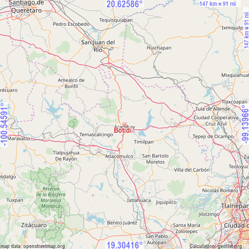
| Upper-left | 20.62586°, | -100.54591° |
| Center: | 19.96639°, | -99.84278° |
| Lower-right: | 19.30416°, | -99.13966° |
| Map W x H: | 147×147 km | = 91.3×91.3mi |
| max Lat: | 32.7° ⇑43.7% North |
| Botidi: | 19.96639° |
| min Lat: | ⇓56.3% South 14.53588° |
| min Long | Botidi | max Long |
| -117.105° | -99.84278° | -86.73105° |
| W 37.9%⇐ | ⇒62.1% E |
Elevation
Elevation of Botidi is 2679 m = 8789 ft, and this is 1425.3 m = 4676 ft above average elevation for this country.
| Max E: |
3497 m = 11473 ft | 3% |
| Botidi | 2679 m 8789 ft | |
| Avg. | 1253.7 m = 4113 ft | |
Min E: |
-1 m = -3 ft | 97% |
See also: Mexico elevation on elevation.city.
Geographical zone
Botidi is located in North Torrid zone (between Equator and Tropic of Cancer). Distance of this Northern Tropic circle is 385.9 km =239.8 mi to North.| Distance of | km | miles | from Botidi |
|---|---|---|---|
| North Pole | 7787 | 4838.6 | to North |
| Arctic Circle | 5181.1 | 3219.4 | to North |
| Tropic Cancer | 385.9 | 239.8 | to North |
| Equator | 2220.1 | 1379.5 | to South |


Nearby cities:
15 places around Botidi: (largest is in red/bold)
• Acambay
1.3 km =0.8 mi,  187°
187°
• Boshindó
5.2 km =3.2 mi,  177°
177°
• Buenavista
6.6 km =4.1 mi,  45°
45°
• Detiña (San Antonio Detiña)
4.3 km =2.7 mi,  275°
275°
• Endeje
0.9 km =0.6 mi,  134°
134°
• Ganzda
2.7 km =1.7 mi,  349°
349°
• La Caridad
2.2 km =1.4 mi,  163°
163°
• La Soledad
8.1 km =5 mi,  233°
233°
• Loma Linda
5.5 km =3.4 mi,  23°
23°
• Pathé
4.4 km =2.7 mi, 175°
• Pueblo Nuevo
8.2 km =5.1 mi,  246°
246°
• San Ildefonso (San Ildefonso Yolotepec)
3.3 km =2.1 mi,  170°
170°
• San Juanico Sector Dos
6.8 km =4.2 mi,  117°
117°
• San Pedro de los Metates
7.7 km =4.8 mi, 192°
• Tixmadeje Chiquito
7.5 km =4.7 mi,  269°
269°
Sources, notices
• [Note1] Compared only with cities in Mexico existing in our database
• [Src1] Map data: © OpenStreetMap contributors (CC-BY-SA)
• [Src2] Other city data from geonames.org with taken over terms of usage.
• [Src3] Geographical zone / Annual Mean Temperature by Robert A. Rohde @ Wikipedia
