Santa Rosa geodata
Santa Rosa (Puebla) is a populated place; located in Mexico in America/Mexico_City (GMT-6) time zone. With population of 3,597 people, there are 2545 cities with bigger population in this country. Compared to other cities in Mexico, 67.6% of cities are located further ↑North; 66.3% of cities are located further ←West and 73.6% of cities have lower elevation than Santa Rosa. Note1


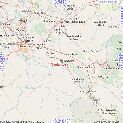
Santa Rosa GPS coordinates[2]
18° 52' 37.344" North, 97° 46' 52.392" West
| Map corner | latitude | longitude |
|---|---|---|
| Upper-left | 19.54101°, | -98.48435° |
| Center: | 18.87704°, | -97.78122° |
| Lower-right: | 18.21043°, | -97.0781° |
| Map W x H: | 147.9×148 km | = 91.9×92mi |
| max Lat: | 32.7° ⇑67.6% North |
| Santa Rosa: | 18.87704° |
| min Lat: | ⇓32.4% South 14.53588° |
| min Long | Santa Rosa | max Long |
| -117.105° | -97.78122° | -86.73105° |
| W 66.3%⇐ | ⇒33.7% E |
Elevation
Elevation of Santa Rosa is 2003 m = 6572 ft, and this is 749.3 m = 2458 ft above average elevation for this country.
| Max E: |
3497 m = 11473 ft | 26.4% |
| Santa Rosa | 2003 m 6572 ft | |
| Avg. | 1253.7 m = 4113 ft | |
Min E: |
-1 m = -3 ft | 73.6% |
See also: Mexico elevation on elevation.city.
Geographical zone
Santa Rosa is located in North Torrid zone (between Equator and Tropic of Cancer). Distance of this Northern Tropic circle is 507 km =315 mi to North.| Distance of | km | miles | from Santa Rosa |
|---|---|---|---|
| North Pole | 7908.1 | 4913.9 | to North |
| Arctic Circle | 5302.2 | 3294.6 | to North |
| Tropic Cancer | 507 | 315 | to North |
| Equator | 2098.9 | 1304.2 | to South |


Nearby cities:
15 places around Santa Rosa: (largest is in red/bold)
• Chipiltepec
6.3 km =3.9 mi,  278°
278°
• Cuapiaxtla de Madero
6.2 km =3.9 mi,  313°
313°
• Francisco Villa
4.1 km =2.5 mi,  152°
152°
• Huixcolotla
5 km =3.1 mi,  11°
11°
• José María Pino Suárez
5.1 km =3.2 mi,  109°
109°
• La Purísima
5.5 km =3.4 mi,  194°
194°
• Rubén Jaramillo
5.6 km =3.5 mi, 149°
• San Antonio Tecolco
2.8 km =1.7 mi,  173°
173°
• San Martín Caltenco
4.1 km =2.5 mi, 282°
• Tecamachalco
5.1 km =3.2 mi,  81°
81°
• Tlaixpan
6 km =3.7 mi,  49°
49°
• Tochtepec
6.1 km =3.8 mi,  226°
226°
• Veracrucito
3.2 km =2 mi,  209°
209°
• Xochimilco
7 km =4.3 mi,  124°
124°
• Zacaola
7 km =4.3 mi,  273°
273°
Sources, notices
• [Note1] Compared only with cities in Mexico existing in our database
• [Src1] Map data: © OpenStreetMap contributors (CC-BY-SA)
• [Src2] Other city data from geonames.org with taken over terms of usage.
• [Src3] Geographical zone / Annual Mean Temperature by Robert A. Rohde @ Wikipedia
