Zacaola geodata
Zacaola (Puebla) is a populated place; located in Mexico in America/Mexico_City (GMT-6) time zone. With population of 2,791 people, there are 3176 cities with bigger population in this country. Compared to other cities in Mexico, 67.5% of cities are located further ↑North; 65.5% of cities are located further ←West and 74.4% of cities have lower elevation than Zacaola. Note1


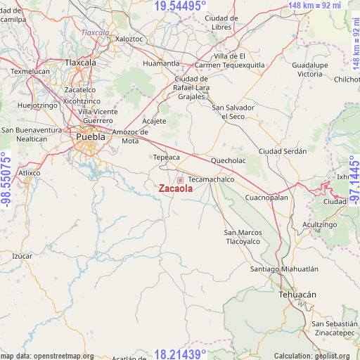
Zacaola GPS coordinates[2]
18° 52' 51.564" North, 97° 50' 51.432" West
| Map corner | latitude | longitude |
|---|---|---|
| Upper-left | 19.54495°, | -98.55075° |
| Center: | 18.88099°, | -97.84762° |
| Lower-right: | 18.21439°, | -97.1445° |
| Map W x H: | 147.9×147.9 km | = 91.9×91.9mi |
| max Lat: | 32.7° ⇑67.5% North |
| Zacaola: | 18.88099° |
| min Lat: | ⇓32.5% South 14.53588° |
| min Long | Zacaola | max Long |
| -117.105° | -97.84762° | -86.73105° |
| W 65.5%⇐ | ⇒34.5% E |
Elevation
Elevation of Zacaola is 2020 m = 6627 ft, and this is 766.3 m = 2514 ft above average elevation for this country.
| Max E: |
3497 m = 11473 ft | 25.6% |
| Zacaola | 2020 m 6627 ft | |
| Avg. | 1253.7 m = 4113 ft | |
Min E: |
-1 m = -3 ft | 74.4% |
See also: Mexico elevation on elevation.city.
Geographical zone
Zacaola is located in North Torrid zone (between Equator and Tropic of Cancer). Distance of this Northern Tropic circle is 506.5 km =314.7 mi to North.| Distance of | km | miles | from Zacaola |
|---|---|---|---|
| North Pole | 7907.7 | 4913.6 | to North |
| Arctic Circle | 5301.8 | 3294.4 | to North |
| Tropic Cancer | 506.5 | 314.7 | to North |
| Equator | 2099.4 | 1304.5 | to South |


Nearby cities:
15 places around Zacaola: (largest is in red/bold)
• Buenavista de Juárez
7.4 km =4.6 mi,  16°
16°
• Chipiltepec
0.9 km =0.6 mi,  53°
53°
• Cuapiaxtla de Madero
4.6 km =2.9 mi,  33°
33°
• Hueyotlipan
2.2 km =1.4 mi,  301°
301°
• Mixtla
5.7 km =3.5 mi, 297°
• Ometepec
3 km =1.9 mi,  191°
191°
• San Hipólito
7.2 km =4.5 mi,  337°
337°
• San Martín Caltenco
3.1 km =1.9 mi,  81°
81°
• San Nicolás Zoyapetlayoca
5.1 km =3.2 mi, 338°
• San Simón Coatepec
5.8 km =3.6 mi,  311°
311°
• Santa Ana Coapan
7.2 km =4.5 mi,  219°
219°
• Santa Rosa
7 km =4.3 mi,  93°
93°
• Tlanepantla
4.6 km =2.9 mi,  244°
244°
• Tochtepec
5.3 km =3.3 mi,  150°
150°
• Veracrucito
6.3 km =3.9 mi,  121°
121°
Sources, notices
• [Note1] Compared only with cities in Mexico existing in our database
• [Src1] Map data: © OpenStreetMap contributors (CC-BY-SA)
• [Src2] Other city data from geonames.org with taken over terms of usage.
• [Src3] Geographical zone / Annual Mean Temperature by Robert A. Rohde @ Wikipedia
