Cuapiaxtla de Madero geodata
Cuapiaxtla de Madero (Puebla) is a seat of a second-order administrative division; located in Mexico in America/Mexico_City (GMT-6) time zone. With population of 7,139 people, there are 1303 cities with bigger population in this country. Compared to other cities in Mexico, 66.7% of cities are located further ↑North; 65.8% of cities are located further ←West and 76.7% of cities have lower elevation than Cuapiaxtla de Madero. Note1
Current local time in Cuapiaxtla de Madero:
05:09 AM, WednesdayDifference from your time zone: hours


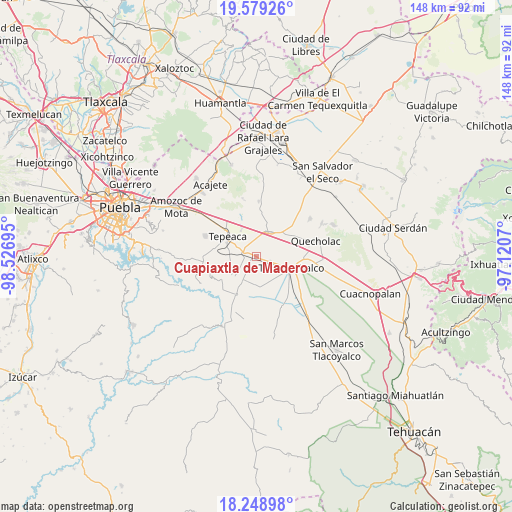
Cuapiaxtla de Madero GPS coordinates[2]
18° 54' 55.584" North, 97° 49' 25.752" West
| Map corner | latitude | longitude |
|---|---|---|
| Upper-left | 19.57926°, | -98.52695° |
| Center: | 18.91544°, | -97.82382° |
| Lower-right: | 18.24898°, | -97.1207° |
| Map W x H: | 147.9×147.9 km | = 91.9×91.9mi |
| max Lat: | 32.7° ⇑66.7% North |
| Cuapiaxtla de Madero: | 18.91544° |
| min Lat: | ⇓33.3% South 14.53588° |
| min Long | Cuapiaxtla de M | max Long |
| -117.105° | -97.82382° | -86.73105° |
| W 65.8%⇐ | ⇒34.2% E |
Elevation
Elevation of Cuapiaxtla de Madero is 2061 m = 6762 ft, and this is 807.3 m = 2649 ft above average elevation for this country.
| Max E: |
3497 m = 11473 ft | 23.3% |
| Cuapiaxtla de Madero | 2061 m 6762 ft | |
| Avg. | 1253.7 m = 4113 ft | |
Min E: |
-1 m = -3 ft | 76.7% |
See also: Mexico elevation on elevation.city.
Geographical zone
Cuapiaxtla de Madero is located in North Torrid zone (between Equator and Tropic of Cancer). Distance of this Northern Tropic circle is 502.7 km =312.4 mi to North.| Distance of | km | miles | from Cuapiaxtla de Madero |
|---|---|---|---|
| North Pole | 7903.9 | 4911.3 | to North |
| Arctic Circle | 5298 | 3292 | to North |
| Tropic Cancer | 502.7 | 312.4 | to North |
| Equator | 2103.2 | 1306.9 | to South |


Nearby cities:
15 places around Cuapiaxtla de Madero: (largest is in red/bold)
• Actipan de Morelos
5.6 km =3.5 mi,  27°
27°
• Buenavista de Juárez
3.3 km =2.1 mi,  352°
352°
• Chipiltepec
3.7 km =2.3 mi,  208°
208°
• Guadalupe Calderón
6.7 km =4.2 mi,  327°
327°
• Hueyotlipan
5.2 km =3.2 mi,  238°
238°
• Huixcolotla
5.5 km =3.4 mi,  83°
83°
• Los Reyes de Juárez
4.3 km =2.7 mi, 29°
• Miguel Negrete
4.1 km =2.5 mi, 352°
• San Hipólito
5.9 km =3.7 mi,  298°
298°
• San Martín Caltenco
3.4 km =2.1 mi,  171°
171°
• San Nicolás Zoyapetlayoca
4.5 km =2.8 mi,  282°
282°
• San Simón Coatepec
6.9 km =4.3 mi,  269°
269°
• Santa Rosa
6.2 km =3.9 mi,  133°
133°
• Santiago Acozac
4.8 km =3 mi,  15°
15°
• Zacaola
4.6 km =2.9 mi, 213°
Sources, notices
• [Note1] Compared only with cities in Mexico existing in our database
• [Src1] Map data: © OpenStreetMap contributors (CC-BY-SA)
• [Src2] Other city data from geonames.org with taken over terms of usage.
• [Src3] Geographical zone / Annual Mean Temperature by Robert A. Rohde @ Wikipedia
