Llano Silleta geodata
Llano Silleta (Guerrero) is a populated place; located in Mexico in America/Mexico_City (GMT-6) time zone. With population of 521 people, there are 16186 cities with bigger population in this country. Compared to other cities in Mexico, 89.8% of cities are located further ↑North; 56% of cities are located further ←West and 63.5% of cities have higher elevation than Llano Silleta. Note1


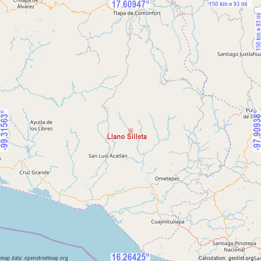
Llano Silleta GPS coordinates[2]
16° 56' 17.016" North, 98° 36' 45" West
| Map corner | latitude | longitude |
|---|---|---|
| Upper-left | 17.60947°, | -99.31563° |
| Center: | 16.93806°, | -98.6125° |
| Lower-right: | 16.26425°, | -97.90938° |
| Map W x H: | 149.6×149.6 km | = 93×93mi |
| max Lat: | 32.7° ⇑89.8% North |
| Llano Silleta: | 16.93806° |
| min Lat: | ⇓10.2% South 14.53588° |
| min Long | Llano Silleta | max Long |
| -117.105° | -98.6125° | -86.73105° |
| W 56%⇐ | ⇒44% E |
Elevation
Elevation of Llano Silleta is 786 m = 2579 ft, and this is 467.7 m = 1534 ft below average elevation for this country.
| Max E: |
3497 m = 11473 ft | 63.5% |
| Avg. | 1253.7 m = 4113 ft | |
| Llano Silleta | 786 m = 2579 ft | |
Min E: |
-1 m = -3 ft | 36.5% |
See also: Mexico elevation on elevation.city.
Geographical zone
Llano Silleta is located in North Torrid zone (between Equator and Tropic of Cancer). Distance of this Northern Tropic circle is 722.6 km =449 mi to North.| Distance of | km | miles | from Llano Silleta |
|---|---|---|---|
| North Pole | 8123.7 | 5047.8 | to North |
| Arctic Circle | 5517.8 | 3428.6 | to North |
| Tropic Cancer | 722.6 | 449 | to North |
| Equator | 1883.3 | 1170.2 | to South |


Nearby cities:
15 places around Llano Silleta: (largest is in red/bold)
• Arroyo Cumiapa
7 km =4.3 mi,  182°
182°
• Aviación
14.9 km =9.3 mi,  329°
329°
• Buena Vista
4.3 km =2.7 mi,  51°
51°
• Camalotillo (El Camalotillo)
8.5 km =5.3 mi,  225°
225°
• Chilixtlahuaca
14.1 km =8.8 mi, 49°
• Cruztomáhuac
12.3 km =7.6 mi,  347°
347°
• El Aserradero
9.6 km =6 mi,  322°
322°
• El Potrerillo (Potrerillo del Rincón)
12.8 km =8 mi,  280°
280°
• El Rincón (Santa Cruz del Rincón)
14.6 km =9.1 mi,  296°
296°
• Iliatenco
14.3 km =8.9 mi, 326°
• Potrerillo Coapinole
10.4 km =6.5 mi,  287°
287°
• Pueblo Hidalgo
4.9 km =3 mi, 288°
• Río Iguapa
7 km =4.3 mi,  57°
57°
• San José Vista Hermosa
9.5 km =5.9 mi,  309°
309°
• Tuxtepec (Cofradía)
8.1 km =5 mi, 295°
Sources, notices
• [Note1] Compared only with cities in Mexico existing in our database
• [Src1] Map data: © OpenStreetMap contributors (CC-BY-SA)
• [Src2] Other city data from geonames.org with taken over terms of usage.
• [Src3] Geographical zone / Annual Mean Temperature by Robert A. Rohde @ Wikipedia
