José María Morelos geodata
José María Morelos (Quintana Roo) is a seat of a second-order administrative division; located in Mexico in America/Cancun (GMT-5) time zone. With population of 11,750 people, there are 819 cities with bigger population in this country. Compared to other cities in Mexico, 51.5% of cities are located further ↓South; 99% of cities are located further ←West and 90.4% of cities have higher elevation than José María Morelos. Note1


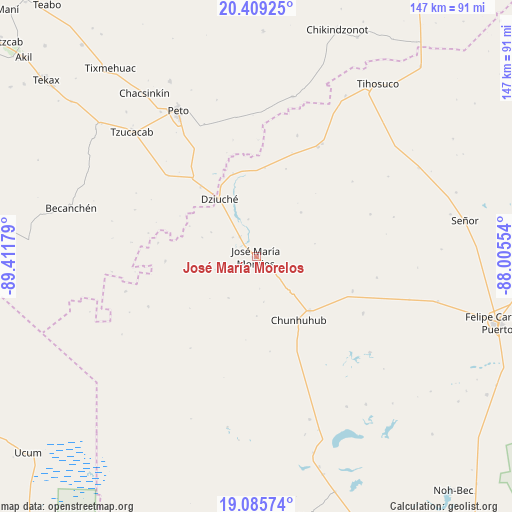
José María Morelos GPS coordinates[2]
19° 44' 55.932" North, 88° 42' 31.176" West
| Map corner | latitude | longitude |
|---|---|---|
| Upper-left | 20.40925°, | -89.41179° |
| Center: | 19.74887°, | -88.70866° |
| Lower-right: | 19.08574°, | -88.00554° |
| Map W x H: | 147.2×147.2 km | = 91.5×91.5mi |
| max Lat: | 32.7° ⇑48.5% North |
| José María Morelos: | 19.74887° |
| min Lat: | ⇓51.5% South 14.53588° |
| min Long | José María Mo | max Long |
| -117.105° | -88.70866° | -86.73105° |
| W 99%⇐ | ⇒1% E |
Elevation
Elevation of José María Morelos is 23 m = 75 ft, and this is 1230.7 m = 4038 ft below average elevation for this country.
| Max E: |
3497 m = 11473 ft | 90.4% |
| Avg. | 1253.7 m = 4113 ft | |
| José María Morelos | 23 m = 75 ft | |
Min E: |
-1 m = -3 ft | 9.6% |
See also: Mexico elevation on elevation.city.
Geographical zone
José María Morelos is located in North Torrid zone (between Equator and Tropic of Cancer). Distance of this Northern Tropic circle is 410.1 km =254.8 mi to North.| Distance of | km | miles | from José María Morelos |
|---|---|---|---|
| North Pole | 7811.2 | 4853.7 | to North |
| Arctic Circle | 5205.3 | 3234.4 | to North |
| Tropic Cancer | 410.1 | 254.8 | to North |
| Equator | 2195.9 | 1364.5 | to South |


Nearby cities:
15 places around José María Morelos: (largest is in red/bold)
• Bulukax
24.8 km =15.4 mi,  344°
344°
• Candelaria
26.2 km =16.3 mi,  266°
266°
• Catmis
34.2 km =21.3 mi,  312°
312°
• Chunhuhub
21.9 km =13.6 mi,  146°
146°
• Dziuche
19.6 km =12.2 mi,  327°
327°
• El Naranjal
14.3 km =8.9 mi,  213°
213°
• Kancabchén
16.5 km =10.3 mi,  256°
256°
• La Esperanza
18.2 km =11.3 mi,  45°
45°
• La Presumida
7.5 km =4.7 mi,  320°
320°
• Othón P. Blanco
34.1 km =21.2 mi,  245°
245°
• Polyuc
21.9 km =13.6 mi,  135°
135°
• San Diego
10.9 km =6.8 mi,  348°
348°
• San Felipe Primero
14.8 km =9.2 mi,  298°
298°
• Santa Gertrudis
8.7 km =5.4 mi, 310°
• X-yatil
29.4 km =18.3 mi,  109°
109°
Sources, notices
• [Note1] Compared only with cities in Mexico existing in our database
• [Src1] Map data: © OpenStreetMap contributors (CC-BY-SA)
• [Src2] Other city data from geonames.org with taken over terms of usage.
• [Src3] Geographical zone / Annual Mean Temperature by Robert A. Rohde @ Wikipedia
