Bulukax geodata
Bulukax (Quintana Roo) is a populated place; located in Mexico in America/Cancun (GMT-5) time zone. With population of 558 people, there are 15286 cities with bigger population in this country. Compared to other cities in Mexico, 56.3% of cities are located further ↓South; 99% of cities are located further ←West and 89% of cities have higher elevation than Bulukax. Note1


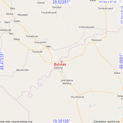
Bulukax GPS coordinates[2]
19° 57' 47.988" North, 88° 46' 19.992" West
| Map corner | latitude | longitude |
|---|---|---|
| Upper-left | 20.62281°, | -89.47535° |
| Center: | 19.96333°, | -88.77222° |
| Lower-right: | 19.30108°, | -88.0691° |
| Map W x H: | 147×147 km | = 91.3×91.3mi |
| max Lat: | 32.7° ⇑43.7% North |
| Bulukax: | 19.96333° |
| min Lat: | ⇓56.3% South 14.53588° |
| min Long | Bulukax | max Long |
| -117.105° | -88.77222° | -86.73105° |
| W 99%⇐ | ⇒1% E |
Elevation
Elevation of Bulukax is 27 m = 89 ft, and this is 1226.7 m = 4025 ft below average elevation for this country.
| Max E: |
3497 m = 11473 ft | 89% |
| Avg. | 1253.7 m = 4113 ft | |
| Bulukax | 27 m = 89 ft | |
Min E: |
-1 m = -3 ft | 11% |
See also: Mexico elevation on elevation.city.
Geographical zone
Bulukax is located in North Torrid zone (between Equator and Tropic of Cancer). Distance of this Northern Tropic circle is 386.2 km =240 mi to North.| Distance of | km | miles | from Bulukax |
|---|---|---|---|
| North Pole | 7787.3 | 4838.8 | to North |
| Arctic Circle | 5181.5 | 3219.6 | to North |
| Tropic Cancer | 386.2 | 240 | to North |
| Equator | 2219.7 | 1379.3 | to South |


Nearby cities:
15 places around Bulukax: (largest is in red/bold)
• Catmis
18.6 km =11.6 mi,  267°
267°
• Dziuche
8.3 km =5.2 mi,  208°
208°
• Huay Max
27.2 km =16.9 mi,  71°
71°
• Ichmul
28 km =17.4 mi,  37°
37°
• José María Morelos
24.8 km =15.4 mi,  164°
164°
• Kancabchén
29.2 km =18.1 mi,  198°
198°
• La Esperanza
22.4 km =13.9 mi,  119°
119°
• La Presumida
18.2 km =11.3 mi,  173°
173°
• Peto
24.1 km =15 mi,  319°
319°
• Saban
25.6 km =15.9 mi, 72°
• San Diego
13.9 km =8.6 mi, 161°
• San Felipe Primero
17.9 km =11.1 mi, 200°
• Santa Gertrudis
18.2 km =11.3 mi,  180°
180°
• Xoy
27.3 km =17 mi,  310°
310°
• Zacalaca
21.4 km =13.3 mi,  59°
59°
Sources, notices
• [Note1] Compared only with cities in Mexico existing in our database
• [Src1] Map data: © OpenStreetMap contributors (CC-BY-SA)
• [Src2] Other city data from geonames.org with taken over terms of usage.
• [Src3] Geographical zone / Annual Mean Temperature by Robert A. Rohde @ Wikipedia
