Dziuche geodata
Dziuche (Quintana Roo) is a populated place; located in Mexico in America/Cancun (GMT-5) time zone. With population of 2,870 people, there are 3098 cities with bigger population in this country. Compared to other cities in Mexico, 55% of cities are located further ↓South; 99% of cities are located further ←West and 86.1% of cities have higher elevation than Dziuche. Note1


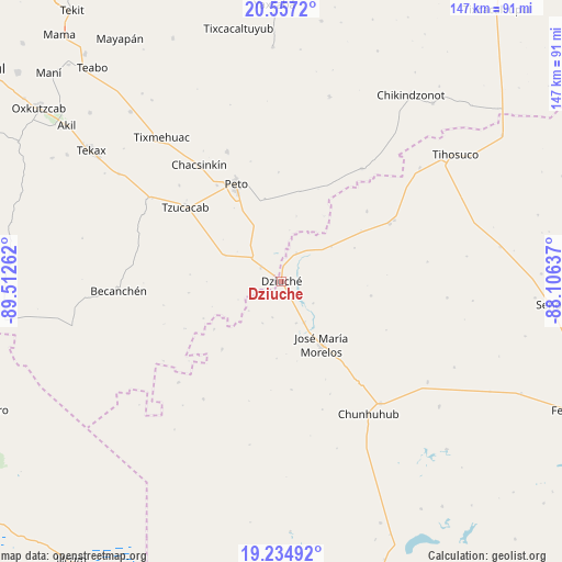
Dziuche GPS coordinates[2]
19° 53' 50.784" North, 88° 48' 34.164" West
| Map corner | latitude | longitude |
|---|---|---|
| Upper-left | 20.5572°, | -89.51262° |
| Center: | 19.89744°, | -88.80949° |
| Lower-right: | 19.23492°, | -88.10637° |
| Map W x H: | 147×147 km | = 91.3×91.3mi |
| max Lat: | 32.7° ⇑45% North |
| Dziuche: | 19.89744° |
| min Lat: | ⇓55% South 14.53588° |
| min Long | Dziuche | max Long |
| -117.105° | -88.80949° | -86.73105° |
| W 99%⇐ | ⇒1% E |
Elevation
Elevation of Dziuche is 38 m = 125 ft, and this is 1215.7 m = 3989 ft below average elevation for this country.
| Max E: |
3497 m = 11473 ft | 86.1% |
| Avg. | 1253.7 m = 4113 ft | |
| Dziuche | 38 m = 125 ft | |
Min E: |
-1 m = -3 ft | 13.9% |
See also: Mexico elevation on elevation.city.
Geographical zone
Dziuche is located in North Torrid zone (between Equator and Tropic of Cancer). Distance of this Northern Tropic circle is 393.5 km =244.5 mi to North.| Distance of | km | miles | from Dziuche |
|---|---|---|---|
| North Pole | 7794.7 | 4843.4 | to North |
| Arctic Circle | 5188.8 | 3224.2 | to North |
| Tropic Cancer | 393.5 | 244.5 | to North |
| Equator | 2212.4 | 1374.7 | to South |


Nearby cities:
15 places around Dziuche: (largest is in red/bold)
• Bulukax
8.3 km =5.2 mi,  28°
28°
• Candelaria
23.7 km =14.7 mi,  221°
221°
• Catmis
16.1 km =10 mi,  294°
294°
• El Naranjal
28.5 km =17.7 mi,  174°
174°
• José María Morelos
19.6 km =12.2 mi,  147°
147°
• Kancabchén
21 km =13 mi,  195°
195°
• La Esperanza
23.7 km =14.7 mi,  98°
98°
• La Presumida
12.2 km =7.6 mi, 151°
• Peto
28.2 km =17.5 mi,  335°
335°
• San Diego
10.2 km =6.3 mi,  124°
124°
• San Felipe Primero
9.7 km =6 mi,  194°
194°
• Santa Gertrudis
11.5 km =7.1 mi,  160°
160°
• Tzucacab
31.8 km =19.8 mi,  307°
307°
• Xoy
30.3 km =18.8 mi,  326°
326°
• Zacalaca
28.9 km =18 mi,  50°
50°
Sources, notices
• [Note1] Compared only with cities in Mexico existing in our database
• [Src1] Map data: © OpenStreetMap contributors (CC-BY-SA)
• [Src2] Other city data from geonames.org with taken over terms of usage.
• [Src3] Geographical zone / Annual Mean Temperature by Robert A. Rohde @ Wikipedia
