Pureza geodata
Pureza (Veracruz) is a populated place; located in Mexico in America/Mexico_City (GMT-6) time zone. With population of 866 people, there are 10100 cities with bigger population in this country. Compared to other cities in Mexico, 59.2% of cities are located further ↑North; 80.8% of cities are located further ←West and 93% of cities have higher elevation than Pureza. Note1


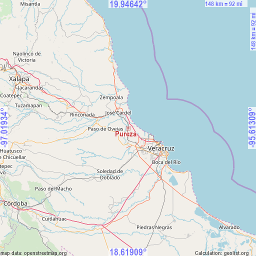
Pureza GPS coordinates[2]
19° 17' 2.76" North, 96° 18' 58.356" West
| Map corner | latitude | longitude |
|---|---|---|
| Upper-left | 19.94642°, | -97.01934° |
| Center: | 19.2841°, | -96.31621° |
| Lower-right: | 18.61909°, | -95.61309° |
| Map W x H: | 147.6×147.6 km | = 91.7×91.7mi |
| max Lat: | 32.7° ⇑59.2% North |
| Pureza: | 19.2841° |
| min Lat: | ⇓40.8% South 14.53588° |
| min Long | Pureza | max Long |
| -117.105° | -96.31621° | -86.73105° |
| W 80.8%⇐ | ⇒19.2% E |
Elevation
Elevation of Pureza is 17 m = 56 ft, and this is 1236.7 m = 4057 ft below average elevation for this country.
| Max E: |
3497 m = 11473 ft | 93% |
| Avg. | 1253.7 m = 4113 ft | |
| Pureza | 17 m = 56 ft | |
Min E: |
-1 m = -3 ft | 7% |
See also: Mexico elevation on elevation.city.
Geographical zone
Pureza is located in North Torrid zone (between Equator and Tropic of Cancer). Distance of this Northern Tropic circle is 461.7 km =286.9 mi to North.| Distance of | km | miles | from Pureza |
|---|---|---|---|
| North Pole | 7862.9 | 4885.8 | to North |
| Arctic Circle | 5257 | 3266.5 | to North |
| Tropic Cancer | 461.7 | 286.9 | to North |
| Equator | 2144.2 | 1332.3 | to South |


Nearby cities:
15 places around Pureza: (largest is in red/bold)
• Cerro Guzmán
8.5 km =5.3 mi,  230°
230°
• Delfino Victoria (Santa Fe)
9.6 km =6 mi,  152°
152°
• El Hatito
8.2 km =5.1 mi,  264°
264°
• El Mango
8.6 km =5.3 mi,  300°
300°
• La Antigua
4.1 km =2.5 mi,  353°
353°
• La Ceiba
7.8 km =4.8 mi, 296°
• Nicolás Blanco (San Pancho)
8 km =5 mi,  343°
343°
• Paso San Juan
9.2 km =5.7 mi,  185°
185°
• Plan del Manantial
9.3 km =5.8 mi,  219°
219°
• Salmoral
7.7 km =4.8 mi,  327°
327°
• San Julián
6 km =3.7 mi,  120°
120°
• Tierra Colorada
8.6 km =5.3 mi, 220°
• Tolome
8.5 km =5.3 mi, 256°
• Vargas
6.3 km =3.9 mi,  184°
184°
• Yucatán
8.3 km =5.2 mi,  324°
324°
Sources, notices
• [Note1] Compared only with cities in Mexico existing in our database
• [Src1] Map data: © OpenStreetMap contributors (CC-BY-SA)
• [Src2] Other city data from geonames.org with taken over terms of usage.
• [Src3] Geographical zone / Annual Mean Temperature by Robert A. Rohde @ Wikipedia
