El Jagüey geodata
El Jagüey (Veracruz) is a populated place; located in Mexico in America/Mexico_City (GMT-6) time zone. With population of 774 people, there are 11290 cities with bigger population in this country. Compared to other cities in Mexico, 79% of cities are located further ↑North; 85.4% of cities are located further ←West and 93% of cities have higher elevation than El Jagüey. Note1


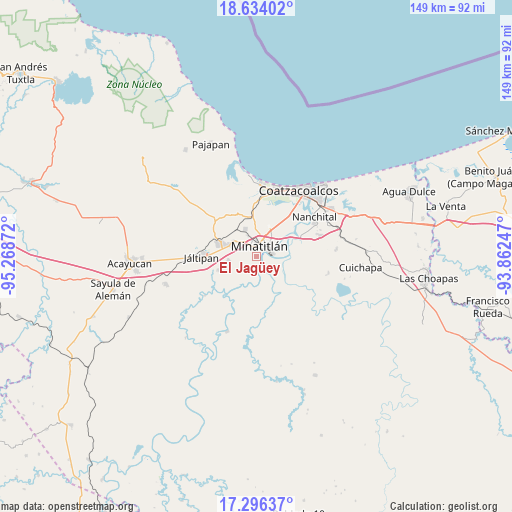
El Jagüey GPS coordinates[2]
17° 57' 59.256" North, 94° 33' 56.124" West
| Map corner | latitude | longitude |
|---|---|---|
| Upper-left | 18.63402°, | -95.26872° |
| Center: | 17.96646°, | -94.56559° |
| Lower-right: | 17.29637°, | -93.86247° |
| Map W x H: | 148.7×148.7 km | = 92.4×92.4mi |
| max Lat: | 32.7° ⇑79% North |
| El Jagüey: | 17.96646° |
| min Lat: | ⇓21% South 14.53588° |
| min Long | El Jagüey | max Long |
| -117.105° | -94.56559° | -86.73105° |
| W 85.4%⇐ | ⇒14.6% E |
Elevation
Elevation of El Jagüey is 17 m = 56 ft, and this is 1236.7 m = 4057 ft below average elevation for this country.
| Max E: |
3497 m = 11473 ft | 93% |
| Avg. | 1253.7 m = 4113 ft | |
| El Jagüey | 17 m = 56 ft | |
Min E: |
-1 m = -3 ft | 7% |
See also: Mexico elevation on elevation.city.
Geographical zone
El Jagüey is located in North Torrid zone (between Equator and Tropic of Cancer). Distance of this Northern Tropic circle is 608.2 km =377.9 mi to North.| Distance of | km | miles | from El Jagüey |
|---|---|---|---|
| North Pole | 8009.4 | 4976.8 | to North |
| Arctic Circle | 5403.5 | 3357.6 | to North |
| Tropic Cancer | 608.2 | 377.9 | to North |
| Equator | 1997.7 | 1241.3 | to South |


Nearby cities:
15 places around El Jagüey: (largest is in red/bold)
• Colonia Luis Donaldo Colosio
5.6 km =3.5 mi,  301°
301°
• Cosoleacaque
8.3 km =5.2 mi, 296°
• El Naranjito
5.6 km =3.5 mi,  308°
308°
• Fraccionamiento los Prados
7.9 km =4.9 mi,  279°
279°
• Hermenegildo J. Aldana
6.6 km =4.1 mi, 311°
• José F. Gutiérrez
8.1 km =5 mi,  324°
324°
• La Esperanza
7.7 km =4.8 mi,  327°
327°
• Las Jacarandas
6.2 km =3.9 mi, 310°
• Las Lomas
1.7 km =1.1 mi,  163°
163°
• Las Ánimas
5.7 km =3.5 mi,  182°
182°
• Limonta
9.7 km =6 mi,  214°
214°
• Mapachapa
7 km =4.3 mi,  358°
358°
• Minatitlán
3.9 km =2.4 mi,  13°
13°
• San Pedro Mártir
4.9 km =3 mi,  286°
286°
• Zaragoza
8.2 km =5.1 mi,  263°
263°
Sources, notices
• [Note1] Compared only with cities in Mexico existing in our database
• [Src1] Map data: © OpenStreetMap contributors (CC-BY-SA)
• [Src2] Other city data from geonames.org with taken over terms of usage.
• [Src3] Geographical zone / Annual Mean Temperature by Robert A. Rohde @ Wikipedia
