La Esperanza geodata
La Esperanza (Veracruz) is a populated place; located in Mexico in America/Mexico_City (GMT-6) time zone. With population of 732 people, there are 11935 cities with bigger population in this country. Compared to other cities in Mexico, 78.4% of cities are located further ↑North; 85.3% of cities are located further ←West and 87.2% of cities have higher elevation than La Esperanza. Note1


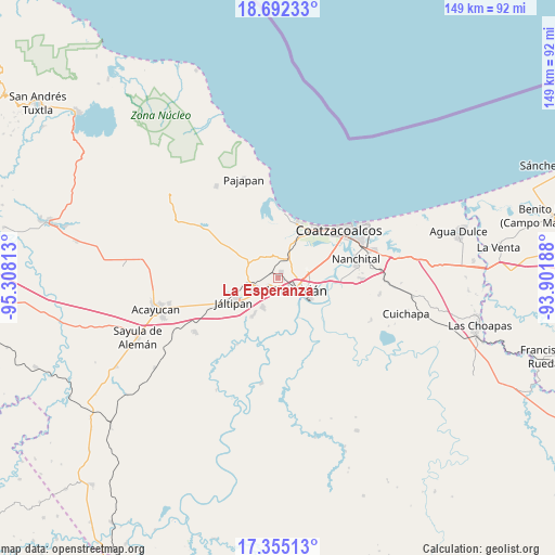
La Esperanza GPS coordinates[2]
18° 1' 30" North, 94° 36' 18" West
| Map corner | latitude | longitude |
|---|---|---|
| Upper-left | 18.69233°, | -95.30813° |
| Center: | 18.025°, | -94.605° |
| Lower-right: | 17.35513°, | -93.90188° |
| Map W x H: | 148.7×148.7 km | = 92.4×92.4mi |
| max Lat: | 32.7° ⇑78.4% North |
| La Esperanza: | 18.025° |
| min Lat: | ⇓21.6% South 14.53588° |
| min Long | La Esperanza | max Long |
| -117.105° | -94.605° | -86.73105° |
| W 85.3%⇐ | ⇒14.7% E |
Elevation
Elevation of La Esperanza is 33 m = 108 ft, and this is 1220.7 m = 4005 ft below average elevation for this country.
| Max E: |
3497 m = 11473 ft | 87.2% |
| Avg. | 1253.7 m = 4113 ft | |
| La Esperanza | 33 m = 108 ft | |
Min E: |
-1 m = -3 ft | 12.8% |
See also: Mexico elevation on elevation.city.
Geographical zone
La Esperanza is located in North Torrid zone (between Equator and Tropic of Cancer). Distance of this Northern Tropic circle is 601.7 km =373.9 mi to North.| Distance of | km | miles | from La Esperanza |
|---|---|---|---|
| North Pole | 8002.9 | 4972.8 | to North |
| Arctic Circle | 5397 | 3353.5 | to North |
| Tropic Cancer | 601.7 | 373.9 | to North |
| Equator | 2004.2 | 1245.4 | to South |


Nearby cities:
15 places around La Esperanza: (largest is in red/bold)
• Barrancas
5.3 km =3.3 mi,  21°
21°
• Chinameca
7.9 km =4.9 mi,  267°
267°
• Colonia Luis Donaldo Colosio
3.6 km =2.2 mi,  189°
189°
• Cosoleacaque
4.4 km =2.7 mi,  228°
228°
• El Jagüey
7.7 km =4.8 mi,  147°
147°
• El Naranjito
3 km =1.9 mi,  183°
183°
• Fraccionamiento los Prados
6.4 km =4 mi,  214°
214°
• Hermenegildo J. Aldana
2.2 km =1.4 mi,  199°
199°
• José F. Gutiérrez
0.6 km =0.4 mi, 272°
• Las Jacarandas
2.5 km =1.6 mi, 192°
• Los Cerritos
6.1 km =3.8 mi,  348°
348°
• Mapachapa
4.1 km =2.5 mi,  82°
82°
• Minatitlán
5.8 km =3.6 mi,  118°
118°
• Oteapan
7 km =4.3 mi,  248°
248°
• San Pedro Mártir
5.2 km =3.2 mi, 186°
Sources, notices
• [Note1] Compared only with cities in Mexico existing in our database
• [Src1] Map data: © OpenStreetMap contributors (CC-BY-SA)
• [Src2] Other city data from geonames.org with taken over terms of usage.
• [Src3] Geographical zone / Annual Mean Temperature by Robert A. Rohde @ Wikipedia
