El Arenal geodata
El Arenal (Veracruz) is a populated place; located in Mexico in America/Mexico_City (GMT-6) time zone. With population of 1,091 people, there are 7974 cities with bigger population in this country. Compared to other cities in Mexico, 62.5% of cities are located further ↓South; 69.3% of cities are located further ←West and 81% of cities have higher elevation than El Arenal. Note1


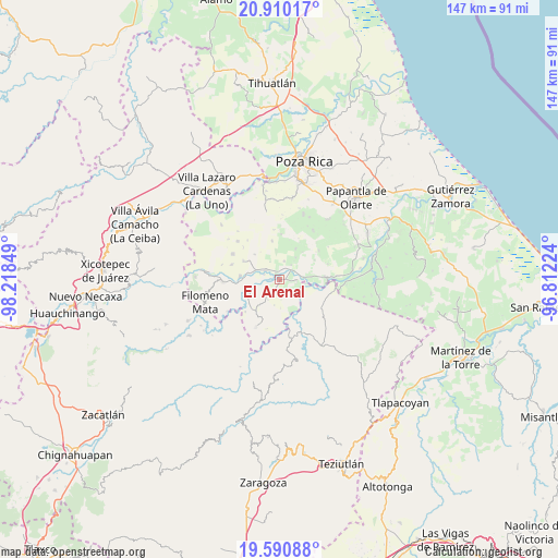
El Arenal GPS coordinates[2]
20° 15' 6.948" North, 97° 30' 55.296" West
| Map corner | latitude | longitude |
|---|---|---|
| Upper-left | 20.91017°, | -98.21849° |
| Center: | 20.25193°, | -97.51536° |
| Lower-right: | 19.59088°, | -96.81224° |
| Map W x H: | 146.7×146.7 km | = 91.2×91.2mi |
| max Lat: | 32.7° ⇑37.5% North |
| El Arenal: | 20.25193° |
| min Lat: | ⇓62.5% South 14.53588° |
| min Long | El Arenal | max Long |
| -117.105° | -97.51536° | -86.73105° |
| W 69.3%⇐ | ⇒30.7% E |
Elevation
Elevation of El Arenal is 82 m = 269 ft, and this is 1171.7 m = 3844 ft below average elevation for this country.
| Max E: |
3497 m = 11473 ft | 81% |
| Avg. | 1253.7 m = 4113 ft | |
| El Arenal | 82 m = 269 ft | |
Min E: |
-1 m = -3 ft | 19% |
See also: Mexico elevation on elevation.city.
Geographical zone
El Arenal is located in North Torrid zone (between Equator and Tropic of Cancer). Distance of this Northern Tropic circle is 354.1 km =220 mi to North.| Distance of | km | miles | from El Arenal |
|---|---|---|---|
| North Pole | 7755.3 | 4818.9 | to North |
| Arctic Circle | 5149.4 | 3199.7 | to North |
| Tropic Cancer | 354.1 | 220 | to North |
| Equator | 2251.8 | 1399.2 | to South |


Nearby cities:
15 places around El Arenal: (largest is in red/bold)
• Adolfo Ruiz Cortines
5.8 km =3.6 mi,  234°
234°
• Buenavista
5.1 km =3.2 mi,  13°
13°
• Chapultepec
6 km =3.7 mi,  211°
211°
• Comalteco
4.6 km =2.9 mi,  94°
94°
• El Ermitaño
5 km =3.1 mi,  175°
175°
• El Pacífico
6.3 km =3.9 mi,  293°
293°
• Entabladero
4.5 km =2.8 mi,  304°
304°
• José María Morelos
5.1 km =3.2 mi,  216°
216°
• La Noria
5.4 km =3.4 mi, 298°
• Ojite de Matamoros
2.2 km =1.4 mi, 90°
• Oriente Medio Día
4.2 km =2.6 mi,  51°
51°
• Oriente Meridiano
5 km =3.1 mi,  37°
37°
• Sabanas de Xalostoc
3.9 km =2.4 mi, 212°
• Sabanita
4.3 km =2.7 mi, 289°
• Zacate Limón
3.1 km =1.9 mi,  197°
197°
Sources, notices
• [Note1] Compared only with cities in Mexico existing in our database
• [Src1] Map data: © OpenStreetMap contributors (CC-BY-SA)
• [Src2] Other city data from geonames.org with taken over terms of usage.
• [Src3] Geographical zone / Annual Mean Temperature by Robert A. Rohde @ Wikipedia
