Zacate Limón geodata
Zacate Limón (Veracruz) is a populated place; located in Mexico in America/Mexico_City (GMT-6) time zone. With population of 686 people, there are 12663 cities with bigger population in this country. Compared to other cities in Mexico, 62% of cities are located further ↓South; 69.3% of cities are located further ←West and 79.7% of cities have higher elevation than Zacate Limón. Note1


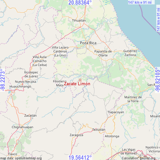
Zacate Limón GPS coordinates[2]
20° 13' 31.008" North, 97° 31' 27.012" West
| Map corner | latitude | longitude |
|---|---|---|
| Upper-left | 20.88364°, | -98.2273° |
| Center: | 20.22528°, | -97.52417° |
| Lower-right: | 19.56412°, | -96.82105° |
| Map W x H: | 146.7×146.7 km | = 91.2×91.2mi |
| max Lat: | 32.7° ⇑38% North |
| Zacate Limón: | 20.22528° |
| min Lat: | ⇓62% South 14.53588° |
| min Long | Zacate Limón | max Long |
| -117.105° | -97.52417° | -86.73105° |
| W 69.3%⇐ | ⇒30.7% E |
Elevation
Elevation of Zacate Limón is 100 m = 328 ft, and this is 1153.7 m = 3785 ft below average elevation for this country.
| Max E: |
3497 m = 11473 ft | 79.7% |
| Avg. | 1253.7 m = 4113 ft | |
| Zacate Limón | 100 m = 328 ft | |
Min E: |
-1 m = -3 ft | 20.3% |
See also: Mexico elevation on elevation.city.
Geographical zone
Zacate Limón is located in North Torrid zone (between Equator and Tropic of Cancer). Distance of this Northern Tropic circle is 357.1 km =221.9 mi to North.| Distance of | km | miles | from Zacate Limón |
|---|---|---|---|
| North Pole | 7758.2 | 4820.7 | to North |
| Arctic Circle | 5152.3 | 3201.5 | to North |
| Tropic Cancer | 357.1 | 221.9 | to North |
| Equator | 2248.8 | 1397.3 | to South |


Nearby cities:
15 places around Zacate Limón: (largest is in red/bold)
• Adolfo Ruiz Cortines
3.9 km =2.4 mi,  264°
264°
• Chapultepec
3.1 km =1.9 mi,  225°
225°
• Chihuixcruz
4.9 km =3 mi,  176°
176°
• Comalteco
6.1 km =3.8 mi,  64°
64°
• El Arenal
3.1 km =1.9 mi,  17°
17°
• El Chacal
6.7 km =4.2 mi,  92°
92°
• El Ermitaño
2.4 km =1.5 mi,  146°
146°
• Entabladero
6.2 km =3.9 mi,  333°
333°
• José María Morelos
2.4 km =1.5 mi,  242°
242°
• La Noria
6.7 km =4.2 mi, 325°
• Ojite de Matamoros
4.3 km =2.7 mi,  46°
46°
• Oriente Medio Día
7 km =4.3 mi,  37°
37°
• Sabanas de Xalostoc
1.2 km =0.7 mi,  253°
253°
• Sabanita
5.4 km =3.4 mi,  324°
324°
• Santa Isabel
3.7 km =2.3 mi,  188°
188°
Sources, notices
• [Note1] Compared only with cities in Mexico existing in our database
• [Src1] Map data: © OpenStreetMap contributors (CC-BY-SA)
• [Src2] Other city data from geonames.org with taken over terms of usage.
• [Src3] Geographical zone / Annual Mean Temperature by Robert A. Rohde @ Wikipedia
