La Guadalupe geodata
La Guadalupe (Veracruz) is a populated place; located in Mexico in America/Mexico_City (GMT-6) time zone. With population of 1,149 people, there are 7545 cities with bigger population in this country. Compared to other cities in Mexico, 75.8% of cities are located further ↑North; 81.6% of cities are located further ←West and 84.7% of cities have higher elevation than La Guadalupe. Note1


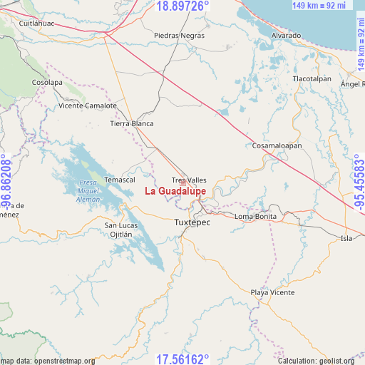
La Guadalupe GPS coordinates[2]
18° 13' 50.592" North, 96° 9' 32.22" West
| Map corner | latitude | longitude |
|---|---|---|
| Upper-left | 18.89726°, | -96.86208° |
| Center: | 18.23072°, | -96.15895° |
| Lower-right: | 17.56162°, | -95.45583° |
| Map W x H: | 148.5×148.5 km | = 92.3×92.3mi |
| max Lat: | 32.7° ⇑75.8% North |
| La Guadalupe: | 18.23072° |
| min Lat: | ⇓24.2% South 14.53588° |
| min Long | La Guadalupe | max Long |
| -117.105° | -96.15895° | -86.73105° |
| W 81.6%⇐ | ⇒18.4% E |
Elevation
Elevation of La Guadalupe is 46 m = 151 ft, and this is 1207.7 m = 3962 ft below average elevation for this country.
| Max E: |
3497 m = 11473 ft | 84.7% |
| Avg. | 1253.7 m = 4113 ft | |
| La Guadalupe | 46 m = 151 ft | |
Min E: |
-1 m = -3 ft | 15.3% |
See also: Mexico elevation on elevation.city.
Geographical zone
La Guadalupe is located in North Torrid zone (between Equator and Tropic of Cancer). Distance of this Northern Tropic circle is 578.9 km =359.7 mi to North.| Distance of | km | miles | from La Guadalupe |
|---|---|---|---|
| North Pole | 7980 | 4958.5 | to North |
| Arctic Circle | 5374.1 | 3339.3 | to North |
| Tropic Cancer | 578.9 | 359.7 | to North |
| Equator | 2027.1 | 1259.6 | to South |


Nearby cities:
15 places around La Guadalupe: (largest is in red/bold)
• Colonia Adolfo Ruiz Cortines (Colonia Obrera)
2.9 km =1.8 mi,  354°
354°
• El Capulín (La Nueva Pochota)
12.6 km =7.8 mi,  269°
269°
• El Nuevo Manantial
8.1 km =5 mi,  299°
299°
• El Porvenir
10.4 km =6.5 mi,  216°
216°
• Gabino Barreda
9.1 km =5.7 mi,  128°
128°
• Las Margaritas
13.5 km =8.4 mi,  281°
281°
• Las Peñitas
10.4 km =6.5 mi,  168°
168°
• Las Yaguas
12.5 km =7.8 mi,  324°
324°
• Los Naranjos
13.8 km =8.6 mi,  357°
357°
• Novara
6.4 km =4 mi,  122°
122°
• Papaloapan
10.4 km =6.5 mi,  138°
138°
• Poblado Tres
9.7 km =6 mi,  47°
47°
• San Isidro
9.5 km =5.9 mi,  200°
200°
• Santa Cruz
9.7 km =6 mi, 135°
• Tres Valles
2.6 km =1.6 mi,  69°
69°
Sources, notices
• [Note1] Compared only with cities in Mexico existing in our database
• [Src1] Map data: © OpenStreetMap contributors (CC-BY-SA)
• [Src2] Other city data from geonames.org with taken over terms of usage.
• [Src3] Geographical zone / Annual Mean Temperature by Robert A. Rohde @ Wikipedia
