Los Naranjos geodata
Los Naranjos (Veracruz) is a populated place; located in Mexico in America/Mexico_City (GMT-6) time zone. With population of 3,573 people, there are 2558 cities with bigger population in this country. Compared to other cities in Mexico, 74.3% of cities are located further ↑North; 81.6% of cities are located further ←West and 87.5% of cities have higher elevation than Los Naranjos. Note1


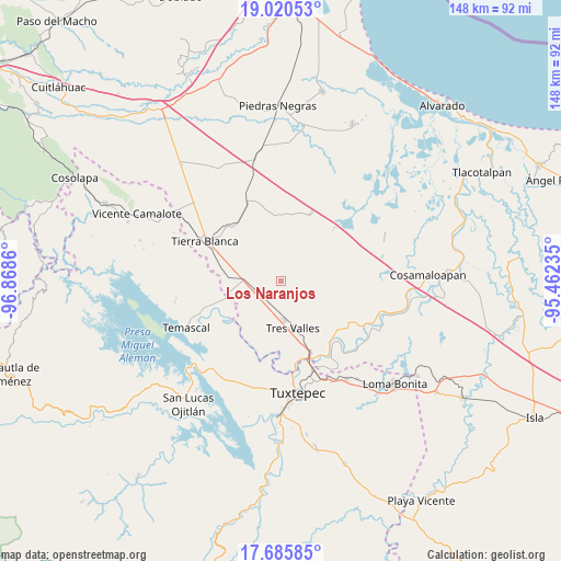
Los Naranjos GPS coordinates[2]
18° 21' 16.128" North, 96° 9' 55.692" West
| Map corner | latitude | longitude |
|---|---|---|
| Upper-left | 19.02053°, | -96.8686° |
| Center: | 18.35448°, | -96.16547° |
| Lower-right: | 17.68585°, | -95.46235° |
| Map W x H: | 148.4×148.4 km | = 92.2×92.2mi |
| max Lat: | 32.7° ⇑74.3% North |
| Los Naranjos: | 18.35448° |
| min Lat: | ⇓25.7% South 14.53588° |
| min Long | Los Naranjos | max Long |
| -117.105° | -96.16547° | -86.73105° |
| W 81.6%⇐ | ⇒18.4% E |
Elevation
Elevation of Los Naranjos is 32 m = 105 ft, and this is 1221.7 m = 4008 ft below average elevation for this country.
| Max E: |
3497 m = 11473 ft | 87.5% |
| Avg. | 1253.7 m = 4113 ft | |
| Los Naranjos | 32 m = 105 ft | |
Min E: |
-1 m = -3 ft | 12.5% |
See also: Mexico elevation on elevation.city.
Geographical zone
Los Naranjos is located in North Torrid zone (between Equator and Tropic of Cancer). Distance of this Northern Tropic circle is 565.1 km =351.1 mi to North.| Distance of | km | miles | from Los Naranjos |
|---|---|---|---|
| North Pole | 7966.2 | 4950 | to North |
| Arctic Circle | 5360.3 | 3330.7 | to North |
| Tropic Cancer | 565.1 | 351.1 | to North |
| Equator | 2040.8 | 1268.1 | to South |


Nearby cities:
15 places around Los Naranjos: (largest is in red/bold)
• Colonia Adolfo Ruiz Cortines (Colonia Obrera)
10.9 km =6.8 mi,  177°
177°
• El Nuevo Manantial
11.7 km =7.3 mi,  213°
213°
• Ideal de Arriba
11.2 km =7 mi,  37°
37°
• La Atalaya
15.6 km =9.7 mi,  289°
289°
• La Granja
9.9 km =6.2 mi,  270°
270°
• La Guadalupe
13.8 km =8.6 mi, 177°
• Las Margaritas
16.7 km =10.4 mi,  228°
228°
• Las Yaguas
7.4 km =4.6 mi,  241°
241°
• Nuevo San José Independencia
11.7 km =7.3 mi,  70°
70°
• Paso Rincón
16.4 km =10.2 mi, 233°
• Poblado Cinco (Nuevo Villa Ojitlán)
13.8 km =8.6 mi,  50°
50°
• Poblado Dos
13.8 km =8.6 mi,  106°
106°
• Poblado Tres
10.7 km =6.6 mi,  132°
132°
• San Nicolás (La Burrera)
9.5 km =5.9 mi,  15°
15°
• Tres Valles
13.2 km =8.2 mi,  166°
166°
Sources, notices
• [Note1] Compared only with cities in Mexico existing in our database
• [Src1] Map data: © OpenStreetMap contributors (CC-BY-SA)
• [Src2] Other city data from geonames.org with taken over terms of usage.
• [Src3] Geographical zone / Annual Mean Temperature by Robert A. Rohde @ Wikipedia
