El Porvenir geodata
El Porvenir (Oaxaca) is a populated place; located in Mexico in America/Mexico_City (GMT-6) time zone. With population of 891 people, there are 9789 cities with bigger population in this country. Compared to other cities in Mexico, 76.8% of cities are located further ↑North; 81.3% of cities are located further ←West and 87.5% of cities have higher elevation than El Porvenir. Note1


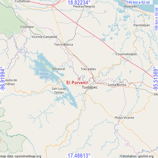
El Porvenir GPS coordinates[2]
18° 9' 19.836" North, 96° 13' 0.516" West
| Map corner | latitude | longitude |
|---|---|---|
| Upper-left | 18.82234°, | -96.91994° |
| Center: | 18.15551°, | -96.21681° |
| Lower-right: | 17.48613°, | -95.51369° |
| Map W x H: | 148.6×148.6 km | = 92.3×92.3mi |
| max Lat: | 32.7° ⇑76.8% North |
| El Porvenir: | 18.15551° |
| min Lat: | ⇓23.2% South 14.53588° |
| min Long | El Porvenir | max Long |
| -117.105° | -96.21681° | -86.73105° |
| W 81.3%⇐ | ⇒18.7% E |
Elevation
Elevation of El Porvenir is 32 m = 105 ft, and this is 1221.7 m = 4008 ft below average elevation for this country.
| Max E: |
3497 m = 11473 ft | 87.5% |
| Avg. | 1253.7 m = 4113 ft | |
| El Porvenir | 32 m = 105 ft | |
Min E: |
-1 m = -3 ft | 12.5% |
See also: Mexico elevation on elevation.city.
Geographical zone
El Porvenir is located in North Torrid zone (between Equator and Tropic of Cancer). Distance of this Northern Tropic circle is 587.2 km =364.9 mi to North.| Distance of | km | miles | from El Porvenir |
|---|---|---|---|
| North Pole | 7988.4 | 4963.8 | to North |
| Arctic Circle | 5382.5 | 3344.5 | to North |
| Tropic Cancer | 587.2 | 364.9 | to North |
| Equator | 2018.7 | 1254.4 | to South |


Nearby cities:
15 places around El Porvenir: (largest is in red/bold)
• Buenos Aires el Apompo
7.9 km =4.9 mi,  260°
260°
• Colonia Adolfo Ruiz Cortines (Colonia Obrera)
12.7 km =7.9 mi,  27°
27°
• El Camarón
5.3 km =3.3 mi,  163°
163°
• El Capulín (La Nueva Pochota)
10.5 km =6.5 mi,  321°
321°
• El Nuevo Manantial
12.4 km =7.7 mi,  355°
355°
• La Guadalupe
10.4 km =6.5 mi,  36°
36°
• Las Peñitas
8.4 km =5.2 mi,  102°
102°
• Macín Chico
11.3 km =7 mi,  210°
210°
• Mazín Grande
10.7 km =6.6 mi,  246°
246°
• Novara
12.5 km =7.8 mi,  66°
66°
• San Isidro
2.9 km =1.8 mi, 101°
• Santa Cruz
13 km =8.1 mi,  83°
83°
• Soledad Macín Chico
10.7 km =6.6 mi,  181°
181°
• Tres Valles
12.6 km =7.8 mi, 42°
• Tuxtepec
12.2 km =7.6 mi,  127°
127°
Sources, notices
• [Note1] Compared only with cities in Mexico existing in our database
• [Src1] Map data: © OpenStreetMap contributors (CC-BY-SA)
• [Src2] Other city data from geonames.org with taken over terms of usage.
• [Src3] Geographical zone / Annual Mean Temperature by Robert A. Rohde @ Wikipedia
