Papaloapan geodata
Papaloapan (Oaxaca) is a populated place; located in Mexico in America/Mexico_City (GMT-6) time zone. With population of 2,302 people, there are 3830 cities with bigger population in this country. Compared to other cities in Mexico, 76.7% of cities are located further ↑North; 81.9% of cities are located further ←West and 89.4% of cities have higher elevation than Papaloapan. Note1


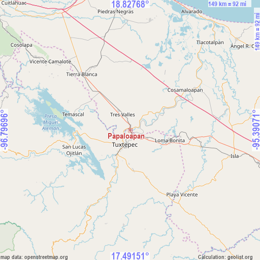
Papaloapan GPS coordinates[2]
18° 9' 39.132" North, 96° 5' 37.788" West
| Map corner | latitude | longitude |
|---|---|---|
| Upper-left | 18.82768°, | -96.79696° |
| Center: | 18.16087°, | -96.09383° |
| Lower-right: | 17.49151°, | -95.39071° |
| Map W x H: | 148.6×148.6 km | = 92.3×92.3mi |
| max Lat: | 32.7° ⇑76.7% North |
| Papaloapan: | 18.16087° |
| min Lat: | ⇓23.3% South 14.53588° |
| min Long | Papaloapan | max Long |
| -117.105° | -96.09383° | -86.73105° |
| W 81.9%⇐ | ⇒18.1% E |
Elevation
Elevation of Papaloapan is 26 m = 85 ft, and this is 1227.7 m = 4028 ft below average elevation for this country.
| Max E: |
3497 m = 11473 ft | 89.4% |
| Avg. | 1253.7 m = 4113 ft | |
| Papaloapan | 26 m = 85 ft | |
Min E: |
-1 m = -3 ft | 10.6% |
See also: Mexico elevation on elevation.city.
Geographical zone
Papaloapan is located in North Torrid zone (between Equator and Tropic of Cancer). Distance of this Northern Tropic circle is 586.6 km =364.5 mi to North.| Distance of | km | miles | from Papaloapan |
|---|---|---|---|
| North Pole | 7987.8 | 4963.4 | to North |
| Arctic Circle | 5381.9 | 3344.2 | to North |
| Tropic Cancer | 586.6 | 364.5 | to North |
| Equator | 2019.3 | 1254.7 | to South |


Nearby cities:
15 places around Papaloapan: (largest is in red/bold)
• Benemérito Juárez
10.7 km =6.6 mi,  115°
115°
• Colonia Adolfo Ruiz Cortines (Colonia Obrera)
12.8 km =8 mi,  326°
326°
• El Camarón
12.8 km =8 mi,  243°
243°
• El Porvenir
13 km =8.1 mi,  267°
267°
• Gabino Barreda
2.1 km =1.3 mi,  6°
6°
• La Guadalupe
10.4 km =6.5 mi,  318°
318°
• Las Peñitas
5.4 km =3.4 mi, 243°
• Novara
4.6 km =2.9 mi,  340°
340°
• Otatitlán
6.6 km =4.1 mi,  74°
74°
• Poblado Tres
14.3 km =8.9 mi,  1°
1°
• San Bartolo
7.8 km =4.8 mi,  190°
190°
• San Isidro
10.3 km =6.4 mi,  263°
263°
• Santa Cruz
0.9 km =0.6 mi,  356°
356°
• Tres Valles
9.8 km =6.1 mi, 333°
• Tuxtepec
8.7 km =5.4 mi,  202°
202°
Sources, notices
• [Note1] Compared only with cities in Mexico existing in our database
• [Src1] Map data: © OpenStreetMap contributors (CC-BY-SA)
• [Src2] Other city data from geonames.org with taken over terms of usage.
• [Src3] Geographical zone / Annual Mean Temperature by Robert A. Rohde @ Wikipedia
