La Guadalupana geodata
La Guadalupana (State of Mexico) is a populated place; located in Mexico in America/Mexico_City (GMT-6) time zone. With population of 1,131 people, there are 7664 cities with bigger population in this country. Compared to other cities in Mexico, 53% of cities are located further ↑North; 62.7% of cities are located further →East and 99.8% of cities have lower elevation than La Guadalupana. Note1


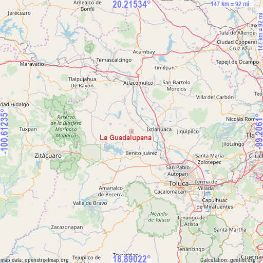
La Guadalupana GPS coordinates[2]
19° 33' 14.904" North, 99° 54' 33.192" West
| Map corner | latitude | longitude |
|---|---|---|
| Upper-left | 20.21534°, | -100.61235° |
| Center: | 19.55414°, | -99.90922° |
| Lower-right: | 18.89022°, | -99.2061° |
| Map W x H: | 147.3×147.3 km | = 91.5×91.5mi |
| max Lat: | 32.7° ⇑53% North |
| La Guadalupana: | 19.55414° |
| min Lat: | ⇓47% South 14.53588° |
| min Long | La Guadalupana | max Long |
| -117.105° | -99.90922° | -86.73105° |
| W 37.3%⇐ | ⇒62.7% E |
Elevation
Elevation of La Guadalupana is 3005 m = 9859 ft, and this is 1751.3 m = 5746 ft above average elevation for this country.
| Max E: |
3497 m = 11473 ft | 0.2% |
| La Guadalupana | 3005 m 9859 ft | |
| Avg. | 1253.7 m = 4113 ft | |
Min E: |
-1 m = -3 ft | 99.8% |
See also: Mexico elevation on elevation.city.
Geographical zone
La Guadalupana is located in North Torrid zone (between Equator and Tropic of Cancer). Distance of this Northern Tropic circle is 431.7 km =268.2 mi to North.| Distance of | km | miles | from La Guadalupana |
|---|---|---|---|
| North Pole | 7832.8 | 4867.1 | to North |
| Arctic Circle | 5227 | 3247.9 | to North |
| Tropic Cancer | 431.7 | 268.2 | to North |
| Equator | 2174.2 | 1351 | to South |


Nearby cities:
15 places around La Guadalupana: (largest is in red/bold)
• Barrio de Centro del Cerrillo
5.1 km =3.2 mi,  247°
247°
• Barrio de San Isidro
6.3 km =3.9 mi,  234°
234°
• Fresno Nichi
4.4 km =2.7 mi,  288°
288°
• La Campanilla
6 km =3.7 mi,  215°
215°
• Mina Vieja
3.6 km =2.2 mi,  267°
267°
• Palos Amarillos (Palos Amarillos Yebuciví)
1.8 km =1.1 mi,  205°
205°
• Piedras Blancas (Piedras Blancas Centro)
4.1 km =2.5 mi, 221°
• Río Frío (Río Frío Yebuciví)
5.2 km =3.2 mi,  203°
203°
• San Andrés del Pedregal
5.2 km =3.2 mi,  54°
54°
• San Antonio de las Huertas
6.5 km =4 mi,  277°
277°
• San Isidro Boxipe
5.6 km =3.5 mi,  20°
20°
• San Miguel Enyege
5.5 km =3.4 mi,  71°
71°
• San Pedro el Alto
4.5 km =2.8 mi,  41°
41°
• Santa Ana Ixtlahuaca (Santa Ana Ixtlahuacingo)
4.1 km =2.5 mi,  33°
33°
• Santa Ana la Ladera
6.2 km =3.9 mi, 41°
Sources, notices
• [Note1] Compared only with cities in Mexico existing in our database
• [Src1] Map data: © OpenStreetMap contributors (CC-BY-SA)
• [Src2] Other city data from geonames.org with taken over terms of usage.
• [Src3] Geographical zone / Annual Mean Temperature by Robert A. Rohde @ Wikipedia
