San Andrés del Pedregal geodata
San Andrés del Pedregal (State of Mexico) is a populated place; located in Mexico in America/Mexico_City (GMT-6) time zone. With population of 2,073 people, there are 4207 cities with bigger population in this country. Compared to other cities in Mexico, 52.4% of cities are located further ↑North; 62.3% of cities are located further →East and 93.9% of cities have lower elevation than San Andrés del Pedregal. Note1
Current local time in San Andrés del Pedregal:
08:35 AM, WednesdayDifference from your time zone: hours


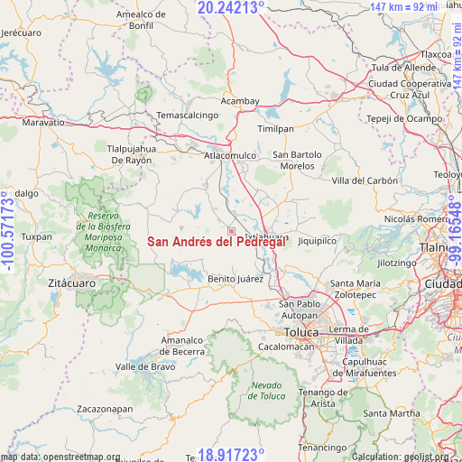
San Andrés del Pedregal GPS coordinates[2]
19° 34' 51.744" North, 99° 52' 6.96" West
| Map corner | latitude | longitude |
|---|---|---|
| Upper-left | 20.24213°, | -100.57173° |
| Center: | 19.58104°, | -99.8686° |
| Lower-right: | 18.91723°, | -99.16548° |
| Map W x H: | 147.3×147.3 km | = 91.5×91.5mi |
| max Lat: | 32.7° ⇑52.4% North |
| San Andrés del Pedregal: | 19.58104° |
| min Lat: | ⇓47.6% South 14.53588° |
| min Long | San Andrés del | max Long |
| -117.105° | -99.8686° | -86.73105° |
| W 37.7%⇐ | ⇒62.3% E |
Elevation
Elevation of San Andrés del Pedregal is 2567 m = 8422 ft, and this is 1313.3 m = 4309 ft above average elevation for this country.
| Max E: |
3497 m = 11473 ft | 6.1% |
| San Andrés del Pedregal | 2567 m 8422 ft | |
| Avg. | 1253.7 m = 4113 ft | |
Min E: |
-1 m = -3 ft | 93.9% |
See also: Mexico elevation on elevation.city.
Geographical zone
San Andrés del Pedregal is located in North Torrid zone (between Equator and Tropic of Cancer). Distance of this Northern Tropic circle is 428.7 km =266.4 mi to North.| Distance of | km | miles | from San Andrés del Pedregal |
|---|---|---|---|
| North Pole | 7829.9 | 4865.3 | to North |
| Arctic Circle | 5224 | 3246 | to North |
| Tropic Cancer | 428.7 | 266.4 | to North |
| Equator | 2177.2 | 1352.8 | to South |


Nearby cities:
15 places around San Andrés del Pedregal: (largest is in red/bold)
• Dolores Enyege
2.5 km =1.6 mi,  120°
120°
• El Rincón de los Perales
6.1 km =3.8 mi,  135°
135°
• Guadalupe Cachi
5.1 km =3.2 mi,  63°
63°
• La Concepción Enyege
3.4 km =2.1 mi, 122°
• La Guadalupana
5.2 km =3.2 mi,  234°
234°
• Palos Amarillos (Palos Amarillos Yebuciví)
6.8 km =4.2 mi, 227°
• San Antonio de los Remedios
6.3 km =3.9 mi,  1°
1°
• San Ignacio del Pedregal
3.3 km =2.1 mi,  30°
30°
• San Isidro Boxipe
3.2 km =2 mi,  313°
313°
• San Juan de las Manzanas
4.6 km =2.9 mi, 136°
• San Miguel Enyege
1.6 km =1 mi, 142°
• San Pedro el Alto
1.3 km =0.8 mi,  286°
286°
• San Pedro el Chico
6.2 km =3.9 mi,  315°
315°
• Santa Ana Ixtlahuaca (Santa Ana Ixtlahuacingo)
2 km =1.2 mi,  281°
281°
• Santa Ana la Ladera
1.7 km =1.1 mi,  354°
354°
Sources, notices
• [Note1] Compared only with cities in Mexico existing in our database
• [Src1] Map data: © OpenStreetMap contributors (CC-BY-SA)
• [Src2] Other city data from geonames.org with taken over terms of usage.
• [Src3] Geographical zone / Annual Mean Temperature by Robert A. Rohde @ Wikipedia
