Santiago Citendejé geodata
Santiago Citendejé (State of Mexico) is a populated place; located in Mexico in America/Mexico_City (GMT-6) time zone. With population of 5,414 people, there are 1712 cities with bigger population in this country. Compared to other cities in Mexico, 52.3% of cities are located further ↓South; 63% of cities are located further →East and 94% of cities have lower elevation than Santiago Citendejé. Note1


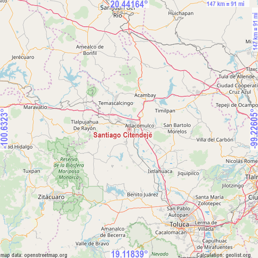
Santiago Citendejé GPS coordinates[2]
19° 46' 53.004" North, 99° 55' 45.012" West
| Map corner | latitude | longitude |
|---|---|---|
| Upper-left | 20.44164°, | -100.6323° |
| Center: | 19.78139°, | -99.92917° |
| Lower-right: | 19.11839°, | -99.22605° |
| Map W x H: | 147.1×147.1 km | = 91.4×91.4mi |
| max Lat: | 32.7° ⇑47.7% North |
| Santiago Citendejé: | 19.78139° |
| min Lat: | ⇓52.3% South 14.53588° |
| min Long | Santiago Citend | max Long |
| -117.105° | -99.92917° | -86.73105° |
| W 37%⇐ | ⇒63% E |
Elevation
Elevation of Santiago Citendejé is 2572 m = 8438 ft, and this is 1318.3 m = 4325 ft above average elevation for this country.
| Max E: |
3497 m = 11473 ft | 6% |
| Santiago Citendejé | 2572 m 8438 ft | |
| Avg. | 1253.7 m = 4113 ft | |
Min E: |
-1 m = -3 ft | 94% |
See also: Mexico elevation on elevation.city.
Geographical zone
Santiago Citendejé is located in North Torrid zone (between Equator and Tropic of Cancer). Distance of this Northern Tropic circle is 406.4 km =252.5 mi to North.| Distance of | km | miles | from Santiago Citendejé |
|---|---|---|---|
| North Pole | 7807.6 | 4851.4 | to North |
| Arctic Circle | 5201.7 | 3232.2 | to North |
| Tropic Cancer | 406.4 | 252.5 | to North |
| Equator | 2199.5 | 1366.7 | to South |


Nearby cities:
15 places around Santiago Citendejé: (largest is in red/bold)
• Atlacomulco de Fabela
6 km =3.7 mi,  70°
70°
• Colonia Río Lerma (Tic Ti)
4.3 km =2.7 mi,  51°
51°
• Concepción Caro
2.4 km =1.5 mi,  117°
117°
• Cuendo
2.9 km =1.8 mi,  317°
317°
• Ejido del Tunal Nenaxi
4.7 km =2.9 mi,  153°
153°
• El Obraje
7.4 km =4.6 mi,  208°
208°
• La Jordana
7.1 km =4.4 mi,  283°
283°
• Manto del Río Ejido
6.5 km =4 mi,  1°
1°
• San Juan Coajomulco
5.2 km =3.2 mi,  232°
232°
• San Lorenzo Tlacotepec
3.9 km =2.4 mi,  27°
27°
• San Miguel Tenochtitlán
2.4 km =1.5 mi,  163°
163°
• Santa Cruz Bombatevi
5.2 km =3.2 mi,  59°
59°
• Santa María Citendejé
0.1 km =0.1 mi,  44°
44°
• Santiago Casandeje
4.4 km =2.7 mi,  252°
252°
• Santo Domingo Shomege (Shomege)
7.7 km =4.8 mi,  22°
22°
Sources, notices
• [Note1] Compared only with cities in Mexico existing in our database
• [Src1] Map data: © OpenStreetMap contributors (CC-BY-SA)
• [Src2] Other city data from geonames.org with taken over terms of usage.
• [Src3] Geographical zone / Annual Mean Temperature by Robert A. Rohde @ Wikipedia
