El Espino Peralta geodata
El Espino Peralta (State of Mexico) is a populated place; located in Mexico in America/Mexico_City (GMT-6) time zone. With population of 548 people, there are 15532 cities with bigger population in this country. Compared to other cities in Mexico, 56.9% of cities are located further ↑North; 57.4% of cities are located further →East and 94.1% of cities have lower elevation than El Espino Peralta. Note1


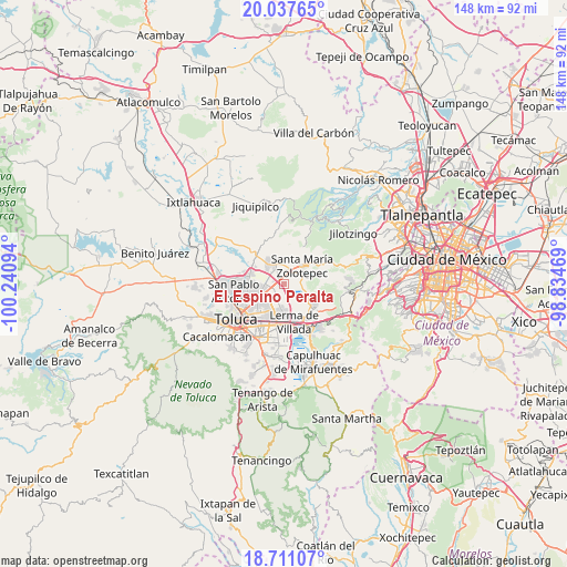
El Espino Peralta GPS coordinates[2]
19° 22' 32.556" North, 99° 32' 16.116" West
| Map corner | latitude | longitude |
|---|---|---|
| Upper-left | 20.03765°, | -100.24094° |
| Center: | 19.37571°, | -99.53781° |
| Lower-right: | 18.71107°, | -98.83469° |
| Map W x H: | 147.5×147.5 km | = 91.7×91.7mi |
| max Lat: | 32.7° ⇑56.9% North |
| El Espino Peralta: | 19.37571° |
| min Lat: | ⇓43.1% South 14.53588° |
| min Long | El Espino Peral | max Long |
| -117.105° | -99.53781° | -86.73105° |
| W 42.6%⇐ | ⇒57.4% E |
Elevation
Elevation of El Espino Peralta is 2576 m = 8451 ft, and this is 1322.3 m = 4338 ft above average elevation for this country.
| Max E: |
3497 m = 11473 ft | 5.9% |
| El Espino Peralta | 2576 m 8451 ft | |
| Avg. | 1253.7 m = 4113 ft | |
Min E: |
-1 m = -3 ft | 94.1% |
See also: Mexico elevation on elevation.city.
Geographical zone
El Espino Peralta is located in North Torrid zone (between Equator and Tropic of Cancer). Distance of this Northern Tropic circle is 451.5 km =280.5 mi to North.| Distance of | km | miles | from El Espino Peralta |
|---|---|---|---|
| North Pole | 7852.7 | 4879.4 | to North |
| Arctic Circle | 5246.8 | 3260.2 | to North |
| Tropic Cancer | 451.5 | 280.5 | to North |
| Equator | 2154.4 | 1338.7 | to South |


Nearby cities:
15 places around El Espino Peralta: (largest is in red/bold)
• Arroyo Vista Hermosa
5 km =3.1 mi,  178°
178°
• Barrio de San Juan
4.3 km =2.7 mi,  0°
0°
• Colonia Adolfo López Mateos
4.3 km =2.7 mi,  13°
13°
• Colonia Emiliano Zapata
2.2 km =1.4 mi,  37°
37°
• Colonia Álvaro Obregón
4.5 km =2.8 mi,  88°
88°
• Guadalupe Totoltepec
4.1 km =2.5 mi,  222°
222°
• La Constitución Toltepec
3.2 km =2 mi,  201°
201°
• La Joya
4.4 km =2.7 mi,  295°
295°
• Pueblo Nuevo Tlalmimilolpan
4.2 km =2.6 mi,  64°
64°
• San Antonio
5.2 km =3.2 mi,  32°
32°
• San Blas Otzacatipan
3 km =1.9 mi,  275°
275°
• San Nicolás Tolentino
4 km =2.5 mi,  242°
242°
• Santa Catarina
5.3 km =3.3 mi, 58°
• Villa Cuauhtémoc
5.1 km =3.2 mi,  334°
334°
• Xonacatlán
3.4 km =2.1 mi,  17°
17°
Sources, notices
• [Note1] Compared only with cities in Mexico existing in our database
• [Src1] Map data: © OpenStreetMap contributors (CC-BY-SA)
• [Src2] Other city data from geonames.org with taken over terms of usage.
• [Src3] Geographical zone / Annual Mean Temperature by Robert A. Rohde @ Wikipedia
