Guadalupe Totoltepec geodata
Guadalupe Totoltepec (State of Mexico) is a populated place; located in Mexico in America/Mexico_City (GMT-6) time zone. With population of 1,755 people, there are 4949 cities with bigger population in this country. Compared to other cities in Mexico, 57.7% of cities are located further ↑North; 57.8% of cities are located further →East and 94.4% of cities have lower elevation than Guadalupe Totoltepec. Note1


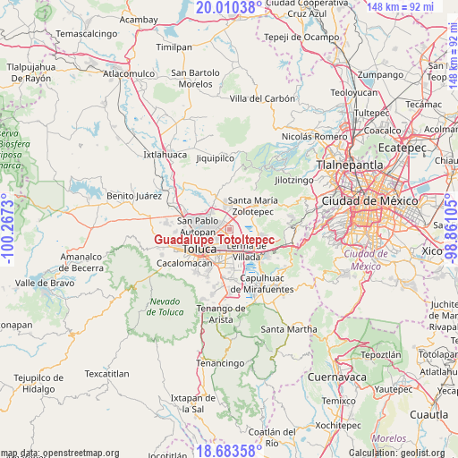
Guadalupe Totoltepec GPS coordinates[2]
19° 20' 53.988" North, 99° 33' 51.012" West
| Map corner | latitude | longitude |
|---|---|---|
| Upper-left | 20.01038°, | -100.2673° |
| Center: | 19.34833°, | -99.56417° |
| Lower-right: | 18.68358°, | -98.86105° |
| Map W x H: | 147.5×147.5 km | = 91.7×91.7mi |
| max Lat: | 32.7° ⇑57.7% North |
| Guadalupe Totoltepec: | 19.34833° |
| min Lat: | ⇓42.3% South 14.53588° |
| min Long | Guadalupe Totol | max Long |
| -117.105° | -99.56417° | -86.73105° |
| W 42.2%⇐ | ⇒57.8% E |
Elevation
Elevation of Guadalupe Totoltepec is 2583 m = 8474 ft, and this is 1329.3 m = 4361 ft above average elevation for this country.
| Max E: |
3497 m = 11473 ft | 5.6% |
| Guadalupe Totoltepec | 2583 m 8474 ft | |
| Avg. | 1253.7 m = 4113 ft | |
Min E: |
-1 m = -3 ft | 94.4% |
See also: Mexico elevation on elevation.city.
Geographical zone
Guadalupe Totoltepec is located in North Torrid zone (between Equator and Tropic of Cancer). Distance of this Northern Tropic circle is 454.6 km =282.5 mi to North.| Distance of | km | miles | from Guadalupe Totoltepec |
|---|---|---|---|
| North Pole | 7855.7 | 4881.3 | to North |
| Arctic Circle | 5249.8 | 3262.1 | to North |
| Tropic Cancer | 454.6 | 282.5 | to North |
| Equator | 2151.3 | 1336.8 | to South |


Nearby cities:
15 places around Guadalupe Totoltepec: (largest is in red/bold)
• Arroyo Vista Hermosa
3.5 km =2.2 mi,  124°
124°
• Colonia los Cedros
4.7 km =2.9 mi,  149°
149°
• El Cerrillo Vista Hermosa
3.6 km =2.2 mi,  140°
140°
• El Espino Peralta
4.1 km =2.5 mi,  42°
42°
• La Constitución Toltepec
1.6 km =1 mi,  88°
88°
• La Joya
5.1 km =3.2 mi,  346°
346°
• San Blas Otzacatipan
3.3 km =2.1 mi,  356°
356°
• San Diego los Padres Cuexcontitlán Sección 5 B
5.9 km =3.7 mi,  301°
301°
• San Francisco Totoltepec
2.4 km =1.5 mi,  156°
156°
• San José Guadalupe Otzacatipan
2.9 km =1.8 mi,  262°
262°
• San Mateo Otzacatipan
4.5 km =2.8 mi,  247°
247°
• San Miguel Totoltepec
3.1 km =1.9 mi,  207°
207°
• San Nicolás Tolentino
1.4 km =0.9 mi,  326°
326°
• San Pedro Totoltepec
4.2 km =2.6 mi,  191°
191°
• Santa María Totoltepec
5.5 km =3.4 mi, 212°
Sources, notices
• [Note1] Compared only with cities in Mexico existing in our database
• [Src1] Map data: © OpenStreetMap contributors (CC-BY-SA)
• [Src2] Other city data from geonames.org with taken over terms of usage.
• [Src3] Geographical zone / Annual Mean Temperature by Robert A. Rohde @ Wikipedia
