San Nicolás Tolentino geodata
San Nicolás Tolentino (State of Mexico) is a populated place; located in Mexico in America/Mexico_City (GMT-6) time zone. With population of 6,798 people, there are 1372 cities with bigger population in this country. Compared to other cities in Mexico, 57.3% of cities are located further ↑North; 58% of cities are located further →East and 94.4% of cities have lower elevation than San Nicolás Tolentino. Note1


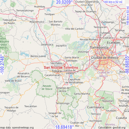
San Nicolás Tolentino GPS coordinates[2]
19° 21' 32.004" North, 99° 34' 18.012" West
| Map corner | latitude | longitude |
|---|---|---|
| Upper-left | 20.0209°, | -100.2748° |
| Center: | 19.35889°, | -99.57167° |
| Lower-right: | 18.69418°, | -98.86855° |
| Map W x H: | 147.5×147.5 km | = 91.7×91.7mi |
| max Lat: | 32.7° ⇑57.3% North |
| San Nicolás Tolentino: | 19.35889° |
| min Lat: | ⇓42.7% South 14.53588° |
| min Long | San Nicolás To | max Long |
| -117.105° | -99.57167° | -86.73105° |
| W 42%⇐ | ⇒58% E |
Elevation
Elevation of San Nicolás Tolentino is 2583 m = 8474 ft, and this is 1329.3 m = 4361 ft above average elevation for this country.
| Max E: |
3497 m = 11473 ft | 5.6% |
| San Nicolás Tolentino | 2583 m 8474 ft | |
| Avg. | 1253.7 m = 4113 ft | |
Min E: |
-1 m = -3 ft | 94.4% |
See also: Mexico elevation on elevation.city.
Geographical zone
San Nicolás Tolentino is located in North Torrid zone (between Equator and Tropic of Cancer). Distance of this Northern Tropic circle is 453.4 km =281.7 mi to North.| Distance of | km | miles | from San Nicolás Tolentino |
|---|---|---|---|
| North Pole | 7854.6 | 4880.6 | to North |
| Arctic Circle | 5248.7 | 3261.4 | to North |
| Tropic Cancer | 453.4 | 281.7 | to North |
| Equator | 2152.5 | 1337.5 | to South |


Nearby cities:
15 places around San Nicolás Tolentino: (largest is in red/bold)
• Arroyo Vista Hermosa
4.8 km =3 mi,  130°
130°
• El Cerrillo Vista Hermosa
5 km =3.1 mi,  142°
142°
• El Espino Peralta
4 km =2.5 mi,  62°
62°
• Guadalupe Totoltepec
1.4 km =0.9 mi,  146°
146°
• La Constitución Toltepec
2.6 km =1.6 mi,  115°
115°
• La Joya
3.8 km =2.4 mi,  353°
353°
• La Y
4.7 km =2.9 mi,  336°
336°
• San Andrés Cuexcontitlán
5.2 km =3.2 mi,  270°
270°
• San Blas Otzacatipan
2.2 km =1.4 mi,  14°
14°
• San Diego los Padres Cuexcontitlán Sección 5 B
4.7 km =2.9 mi,  294°
294°
• San Francisco Totoltepec
3.8 km =2.4 mi, 152°
• San José Guadalupe Otzacatipan
2.6 km =1.6 mi,  233°
233°
• San Mateo Otzacatipan
4.4 km =2.7 mi, 228°
• San Miguel Totoltepec
3.9 km =2.4 mi,  189°
189°
• San Pedro Totoltepec
5.3 km =3.3 mi,  180°
180°
Sources, notices
• [Note1] Compared only with cities in Mexico existing in our database
• [Src1] Map data: © OpenStreetMap contributors (CC-BY-SA)
• [Src2] Other city data from geonames.org with taken over terms of usage.
• [Src3] Geographical zone / Annual Mean Temperature by Robert A. Rohde @ Wikipedia
