San Nicolás Peralta geodata
San Nicolás Peralta (Morelos) is a populated place; located in Mexico in America/Mexico_City (GMT-6) time zone. With population of 4,573 people, there are 2010 cities with bigger population in this country. Compared to other cities in Mexico, 57.3% of cities are located further ↑North; 56.8% of cities are located further →East and 94.5% of cities have lower elevation than San Nicolás Peralta. Note1


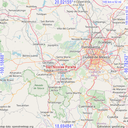
San Nicolás Peralta GPS coordinates[2]
19° 21' 34.344" North, 99° 29' 7.98" West
| Map corner | latitude | longitude |
|---|---|---|
| Upper-left | 20.02155°, | -100.18868° |
| Center: | 19.35954°, | -99.48555° |
| Lower-right: | 18.69484°, | -98.78243° |
| Map W x H: | 147.5×147.5 km | = 91.7×91.7mi |
| max Lat: | 32.7° ⇑57.3% North |
| San Nicolás Peralta: | 19.35954° |
| min Lat: | ⇓42.7% South 14.53588° |
| min Long | San Nicolás Pe | max Long |
| -117.105° | -99.48555° | -86.73105° |
| W 43.2%⇐ | ⇒56.8% E |
Elevation
Elevation of San Nicolás Peralta is 2584 m = 8478 ft, and this is 1330.3 m = 4365 ft above average elevation for this country.
| Max E: |
3497 m = 11473 ft | 5.5% |
| San Nicolás Peralta | 2584 m 8478 ft | |
| Avg. | 1253.7 m = 4113 ft | |
Min E: |
-1 m = -3 ft | 94.5% |
See also: Mexico elevation on elevation.city.
Geographical zone
San Nicolás Peralta is located in North Torrid zone (between Equator and Tropic of Cancer). Distance of this Northern Tropic circle is 453.3 km =281.7 mi to North.| Distance of | km | miles | from San Nicolás Peralta |
|---|---|---|---|
| North Pole | 7854.5 | 4880.6 | to North |
| Arctic Circle | 5248.6 | 3261.3 | to North |
| Tropic Cancer | 453.3 | 281.7 | to North |
| Equator | 2152.6 | 1337.6 | to South |


Nearby cities:
15 places around San Nicolás Peralta: (largest is in red/bold)
• Barranca Grande
3 km =1.9 mi,  19°
19°
• Colonia Adolfo López Mateos
5.3 km =3.3 mi,  30°
30°
• Colonia Agrícola Analco
1.6 km =1 mi,  134°
134°
• Colonia Reforma Tlalmimilolpan
3.2 km =2 mi,  353°
353°
• Colonia Álvaro Obregón
2.2 km =1.4 mi,  333°
333°
• La Manga (La Laguna)
2.6 km =1.6 mi,  178°
178°
• Pueblo Nuevo Tlalmimilolpan
4 km =2.5 mi,  335°
335°
• San Francisco Xochicuautla
4.5 km =2.8 mi,  70°
70°
• San Mateo Atarasquíllo
4.8 km =3 mi,  148°
148°
• San Pedro Huitzizilapan
5.2 km =3.2 mi,  8°
8°
• Santa Catarina
4.7 km =2.9 mi, 347°
• Santa María Atarasquillo
3.9 km =2.4 mi, 153°
• Santa María Tlalmimilolpan
3.9 km =2.4 mi, 23°
• Santiago Analco
4.7 km =2.9 mi, 131°
• Zacamulpa Tlalmimilolpan
5.3 km =3.3 mi,  51°
51°
Sources, notices
• [Note1] Compared only with cities in Mexico existing in our database
• [Src1] Map data: © OpenStreetMap contributors (CC-BY-SA)
• [Src2] Other city data from geonames.org with taken over terms of usage.
• [Src3] Geographical zone / Annual Mean Temperature by Robert A. Rohde @ Wikipedia
